| |
 Resources consulted for Gloucestershire A Descriptive Catalogue of the Printed Maps of Gloucestershire 1577-1911 Bristol and Gloucestershire Archaeological Society I912. A Bibliography of County Maps - Large Scale County Maps of England. Tooley R.V. The Printed Maps in the Atlases of Great Britain and Ireland1579-1870 Chubb Thomas Dawson 1927 |
 To Resize Images:
Hold CTRL and use mouse wheel |
Bristol 1748 Robt. Rickarts
Glocestershire 1579 Christopher Saxton for his English Atlas (Image courtesy of The Mechanical Curator & Wikimedia)
Bristol 1581 Georg Braun and Franz Hogenburg
Gloucestershire 1605 Pieter van den Keere in his Atlas of the British Isles (Chubb p.15)
Gloucestershire 1607 Christopher Saxton edited and improved by Wm. Kip (Chubb p.9 XVIII)
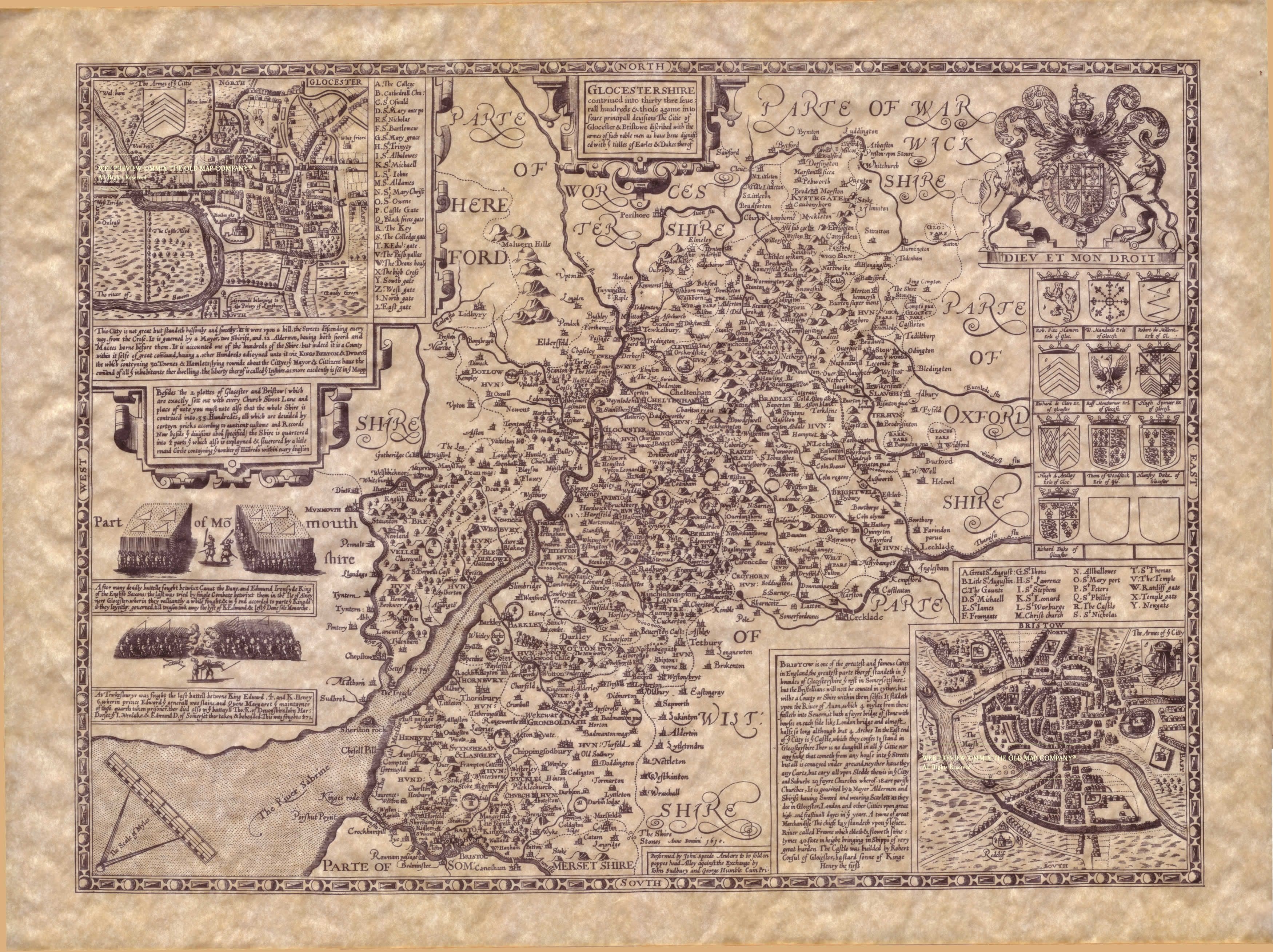
Gloucestershire 1610 John Speed in The theatre of the empire of Great Britaine (Chubb p.23 XXII)
Gloucestershire 1612 Michael Drayton to illustrate his Polyolbion (Chubb XXXV)
Gloucestershire 1645 Jean Blaeu in Atlas Novus (Chubb p.65 LXX) (Image courtesy of The British Library-King's Topographical Collection
Glocestershire 1662 John Speed in A Prospect of the Most Famous Parts of the World (Roger Rea Edition) (Image courtesy of The British Library King's Collection Maps K.To)
Gloucester 1667 Joan Blaeu in Le Grand Atlas volume 5
(Image courtesy of The British Library King's Collection Maps K.Top)
Glocester 1670 Richard Blome
Kingswood Chase:1672
An Exact Delineation of the Famous Citty of Bristol and Suburbs 1673 James Millerd and William Cuningham
(Image courtesy of The British Library Maps K.TOP.37.32.2.
Gloucester 1676 Robert Morden Playing Card
Plan of Bristol 1689 Phillip Lea after John Speed
Gloucester Shire 1695 Robert Morden for Camden's Britannia (Chubb p:93 CXIII)
(Image courtesy of Yale University Library)
Gloucestershire 1695 John Seller in Anglia Contracta
Gloucestershire 1690 Phillip Lea after Christopher Saxton
(Image courtesy of Princeton Historic Map Collection)
Gloucestershire and Monmouthshire 1712 Henry Overton (Image courtesy of The British Library King's Collection. Maps K.Top.13.63.)
Plan of Bristol 1713 Alphonsus Lasor a Varea and William Kip
Gloucestershire 1715 Shenk and Valk after Jan Jansson in Atlas Van der Hagen
Gloucestershire with inset plans of Bristol & Gloucester 1720 Henry Overton
(Image courtesy of The British Library- Kings Collection)
Gloucestershire 1720-1743 John Speed (1610 Henry Overton Edition.) (Image courtesy of The British Library- Kings Collection) Maps K.Top.13.61
The Mannor of Kings Weston 1720 anon
(Image courtesy of The British Library King's Collection.Maps K.Top.13.77.1.a. )
Gloucester 1724 Herman Moll in A New Description of England and Wales (Chubb CLX: CLXI) (Image courtesy of The British Library-King's Topographical Collection
Gloucestershire 1731 Richard Blome in his Britannia.
A Plan of the City of Bristol (Sheet 1 of 2) 1742 Jean Rocque
(Image courtesy of Biblioteca Digital Hispanica)
A Plan of the City of Bristol (Sheet 2 of 2) 1742 Jean Rocque
(Image courtesy of Biblioteca Digital Hispanica)
Gloucestershire 1742 Thomas Badeslade in Chorographia Britanniae (Chubb p.135 CLXXIIV)
A Plan of Bristol 1742 John Rocque engr. John Pine (Image courtesy of The Mechanical Curator & Wikimedia)
Gloucester 1744 J. Cowley & R. Dodsley in Geography of England (Chubb p.141 CLXXXIII )
Gloucestershire 1746 Samuel Simpson in The Agreeable Historian...
(Chubb p.141 XXXIV)
Gloucestershire 1749 Emanuel Bowen in The Large English Atlas Chubb p.157 CXCV)
(Image Courtesy of Biblioteca National de Espana
An Exact Delineation of the Famous City of Bristol 1762 James Millerd (Image courtesy of the British Library)
The City of Gloucester 1768 Herman Moll for Sir Robert Atkyns' Ancient and Present State of Glocestershire
A Map of the Country 11 Miles Around the City of Bristol - (Sheet 1 of 2) 1769 Benjamin Donne
(Image courtesy of The British Library: King's Collection Maps K.Top)
A Map of the Country 11 Miles Around the City of Bristol - (Sheet 2 of 2) 1769 Benjamin Donne
(Image courtesy of The British Library: King's Collection Maps K.Top)
A Plan of the City of Gloucester 1769 Henry Mutlow & Richard Hall
Gloucestershire 1770 Henry Overton Reissue of Speed's map of 1610 in The English Atlas.
(Image courtesy of The British Library King's Collection)
Gloucestershire 1777 Isaac Taylor
(Image courtesy of The British Library-King's Topographical Collection
Gloucestershire 1780 Samuel Leigh in A Topographical Dictionary of England
Gloucestershire 1780 Robert Creighton for Samuel Lewis in his Pocket Atlas of England and Wales
A Plan of the City of Gloucester 1782 Richard Hall
(Image courtesy of The British Library King's Collection. Maps K.Top.13.67.2.)
Gloucestershire 1786 Thomas Kitchen in The Antiquities of England and Wales (Chubb p.210 CCLVII)
Gloucestershire 1786 ( Sheet 01) Isaac Taylor (Image courtesy of Biblioteca Digital Espana)
Gloucestershire 1786 (Sheet 02) Isaac Taylor (Image courtesy of Biblioteca Digital Espana)
Gloucester 1793 John Cary in his New and Correct English Atlas (Chubb p.213 CCLX)
(Image courtesy of New York Library Digital Collections)
Oakley Park 1800 Isaac Taylor
Plan of the Home Park in Cirencester 1800 Isaac Taylor
The county of Glocester 1800 Isaac Taylor
Image courtesy of Harvard University Library)
Plan of Glocester 1801 George Cole and John Roper: intended for inclusion in The Beauties of Britain but published in The British Atlas
Plan of the City of Glocester 1803 Edward Wedlake Brayley
Gloucestershire 1803 John Aikin in England Delineated "A simplified Atlas to make my young countrymen better acquainted than they are usually found to be with their native land" (Image courtesy of The Mechanical Curator & Wikimedia)
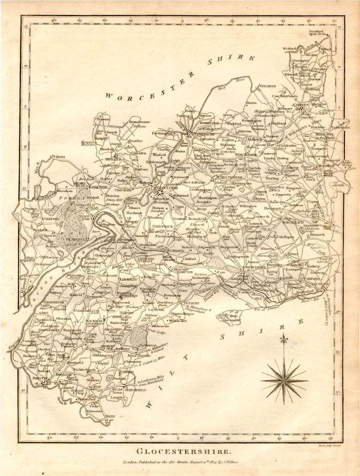
The County of Glocester 1805 Samuel Neele for Dugdales The New English Traveller
Cheltenham 1806 Edward Mitchell
(Image courtesy of The British Library-King's Topographical Collection)
Gloucestershire 1808 Benjamin Pitts Capper in A Topographical Dictionary of the United Kingdom (Chubb p.245 CCCXXVII)
Wikimedia
Gloucestershire 1809 Henry Cooper in An Atlas of the British Islands
(Chubb p.245 CCCXXIII)
Plan of the city of Gloucester 1809 George Cole and John Roper Chubb p.250 CCCXXXIX)
The Town of Cheltenham 1810 Edward Mitchell
(Image courtesy of The British Library King's Collection. Maps K.Top.13.66.1.
Gloucestershire 1810 George Cole and John Roper in their British Atlas
Chubb p.250 CCCXXXIX)
(Image courtesy of The British Library-King's Topographical Collection
Glocestershire 1813 Benjamin Pitts Capper for A Topographical Dictionary of the United Kingdom
(Image courtesy of The British Library King's Collection)
Gloucestershire 1814 John Cary for Cary's Traveller's Companion (Chubb p.220 CCLXXIII)
Plan of Clifton and Hotwells 1815 anon
Donne's New and Correct New Map of Bristol: Clifton and the Hot Wells 1815 Benjamin Donne
(Image courtesy of The British Library: King's Collection. Maps K.TOP.37.34.1.).
Glocestershire 1819 Ellis's New and Correct Atlas Chubb p.266 CCCLXIII)
Gloucestershire 1822 Samuel Leigh in Leigh's New Pocket Atlas
Gloucestershire 1822 Robert Creighton for (Samuel) Leigh's New Pocket Atlas
Glocestershire 1824 George Gray in Gray's New Book of Roads (Chubb p.281 CCCXCII
Glocestershire 1829 Benjamin Pits Capper in A Topographical Dictionary of the Unied Kingdom (Image courtesy of The British Library-Mechanical Curator)
Gloucestershire 1833 Sydney Hall in his New British Atlas (Chubb p.273 CCCLXXIV)
Gloucestershire 1834 C. and J. Greenwood in Atlas of the Counties of England (Chubb CCCCLVII1a) (Image courtesy of www.davidrumsey.com)
Chippenham 1835 Robert Kearsley Dawson for The Boundaries Commission
Tewksbury 1835 Robert Creighton and J. & C. Walker
(Chubb p.322 CCCCLXIV)
Gloucester 1835 Robert Creighton and J: C. Walker (Chubb p.322 CCCCLXIV)
Cirencester 1835 Robert Creighton for Lewis's Topographical Dictionary
Cirencester (Detail) 1835 Robert Creighton for Lewis's Topographical Dictionary
Gloucestershire 1835 Robert Kearsley Dawson for The Boundaries Commission(Chubb p.322 CCCCLXIV)
Stroud 1835 Robert Creighton for Lewis's Topographical Dictionary
(Chubb p.322 CCCCLXIV)
Stroud 1835 (Detail) Robert Creighton for Lewis's Topographical Dictionary
(Chubb p.322 CCCCLXIV)
Gloucestershire 1836 Sidney Hall in The New British Atlas (Chubb p. 314 CCCCLI)
City of Gloucester 1839 J. Rudge in The History and Antiquities of Gloster
Gloucestershire 1842 J. Pigot in Pigot & Co.'s British Atlas of the Counties of England Chubb p.321 CCCCLXII)
Gloucestershire 1842 James Pigot in A Pocket Topography and Gazetteer of England (Image courtesy of The British Library King's Collection Maps K.TOP
The Stranger's Guide through Cheltenham 1843 H. Davies
(Image courtesy of The British Library King's Collection Maps K.TOP)
Plan of Gloucester 1843 Sir Joseph Causton
Plan of Bristol 1851 Rapkin & Tallis
Bristol Channel 1860 Alexander Fullarton
Gloucestershire 1868 William Hughes for the National Gazetteer
Plan of Bristol (with Street Index) 1872 John F. Trew
Plan of Bristol 1883 Adam Black in Black's Guide To England and Wales
Plan of Gloucester 1883 Adam Black in Black's Guide To England and Wales
The History and Antiquities of Gloucester, etc , 1815. Thomas Rudge (Image courtesy of The Mechanical Curator & Wikimedia)
Bristol 1884 A.& C. Black (Image courtesy of The Mechanical Curator & Wikimedia)
Cheltenham 1884 A. & C. Black (Image courtesy of The Mechanical Curator & Wikimedia)
Southampton and Environs 1884 (top sheet) A. & C Black (Image courtesy of The Mechanical Curator & Wikimedia
Southampton and Environs 1884 ( Bottom Sheet) A. & C. Black (Image courtesy of The Mechanical Curator & Wikimedia)
Gloucestershire 1886 Stanford's Parliamentary Atlas
Parliamentary Divisions in Bristol 1885 Stanford's Parliamentary Atlas
Bristol 1903 John Fletcher Trew
Bristol 1920 F. G. Lewin
.jpg)
.jpg)
(Image%20courtesy%20of%20The%20British%20Library%20King's%20Collection%20Maps%20K.Top).jpg)
%20Princeton%20Historic%20Map%20Collection.jpg)
.jpg)
%20(Image%20courtesy%20of%20The%20British%20Library%20King's%20Collection.Maps%20K.Top.13.77.1.a.%20).jpg)
%20Jean%20Rocque%20(Image%20courtesy%20of%20Biblioteca%20Digital%20Hispanica)%20.jpg)
%20Jean%20Rocque%20(Image%20courtesy%20of%20Biblioteca%20Digital%20Hispanica)%20.jpg)
.jpg)
(Image%20Courtesy%20of%20Biblioteca%20National%20de%20E.jpg)
.jpg)
%201769%20Benjamin%20Donne%20(Image%20courtesy%20of%20The%20British%20Library,%20King's%20Collection%20Maps%20K.Top.jpg)
.jpg)
.jpg)
%20Isaac%20Taylor%20(Image%20courtesy%20of%20Biblioteca%20Digital%20Espana.jpg)
%20Isaac%20Taylor%20(Image%20courtesy%20of%20Biblioteca%20Digital%20Espana.jpg)
.jpg)
.jpg)
%20.jpg)
..jpg)
%20.jpg)
%20(Image%20courtesy%20of%20www.davidrumsey.com).jpg)
%201835%20Robert%20Creighton%20for%20Lewis's%20Topographical%20Dictionary.jpg)
%20.jpg)
%201872%20John%20F.%20Trew%20.jpg)
.jpg)
%20.jpg)
%20%20.jpg)
%20%20A.%20&%20C%20Black%20(Image%20courtesy%20of%20The%20Mechanical%20Curator%20&%20Wikimedia)%20.jpg)
%20.jpg)