| |
Home Resources consulted for Sussex: A Bibliography of County Maps - Large Scale County Maps of England. Tooley R.V. The Printed Maps in the Atlases of Great Britain and Ireland1579-1870 Chubb Thomas Dawson 1927 |

To resize image:
L-click on image or hold CTRL and use mouse scroll-wheel |
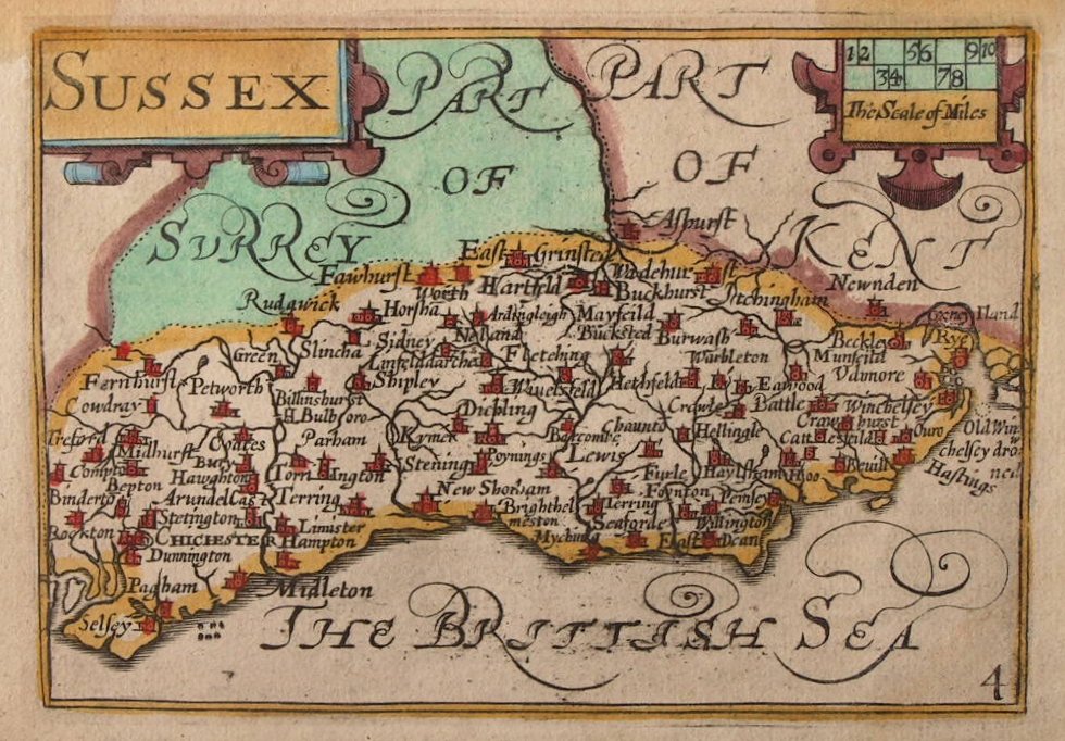
Sussex 1564 Gerard Mercator in Anglia & Scotiae D& Hiberniae Nova Descriptio
A New Map of Sussex 1565 Corrected and amended by John Overton
Staffordshire 1579 Christopher Saxton
Plan of Chichester 1595 John Norden
Sussex 1610 John Norden and William Kip after Christopher Saxton for Camden's Britannia (Chubb p.20 XVIII )
Sussex 1610 Pieter van den Keere (Chubb LX)
Sussex 1616 John Speed in The Theatre of the Empire of Great Britaine (Chubb p.23 XXII)
Sussex 1626 John Bill in his Abridgement of Camden's Britannia
Sussex 1646 Jan Jansson (Chubb p.65 LXX)
(image courtesy of The British Library via Flickr)
Sussex 1645 Joan Blaeu in Atlas Novus (Image courtesy of The British Library King's Collection Maps K.TOP.42.1.
Sussex 1662 John Speed in A Prospect of the Most Famous Parts of the World (Roger Rea Edition)
(Image courtesy of The British Library King's Collection Maps K.TOP)
The Description of the Town and Harbour of Rye 1665 Gulielmus Ham
Sussex 1673 Richard Blome in his Britannia
Sussex 1690 Robert Morden in Camden's Britannia (Chubb p. 93 CXIII)
(image courtesy of Yale University Library)
Rotherhyde 1693 Captain Grenville Collins
Sussex 1695 Robert Morden for Camden's Britannia (image Courtesy of the British Library
Sussex 1701 John Sellar in Anglia Contracta
Map of Sussex Corrected 1714. H. Overton: from a collection of 37 Maps of the counties of England: being reprints: of J. Speeds maps
(Image courtesy of The British Library King's Collection Maps K.TOP
Sussex 1720 Emanuel Bowen in Britannia Depicta (Chubb p.117 CXLVII)
(Image courtesy of The British Library King's Collection Maps K.TOP.42.23.1.
Sussex 1724 Herman Moll
(Image courtesy of The British Library King's Collection Maps K.TOP.42.2..)
Sussex 1730 Charles Price
(Image courtesy of The British Library-King's Topographical Collection)
Sussex. 1730 (Sheet 1 of 2) Richard Budgeon 1730 An Actual Survey of the County of Sussex (Image courtesy of The British Library King's Collection Maps K.TOP.42.3.a.f.)
Sussex 1730 (Sheet 2 of 2 ) An Actual Survey of the County of Sussex 1739
(Image courtesy of The British Library King's Collection Maps K.TOP.42.3.a.f.)
Sussex 1741 Thomas Badeslade and William Toms in Chorographia Britanniae (Chubb 134 CLXX)
Sussex 1750 Emanuel Bowen and Thomas Kitchin in The Large English Atlas (Chubb p.159 CXCVI )
Sussex 1756 Emanuel Bowen for Benjamin Martin's The Natural History of England (Chubb p.177 CCXV)
Plan of Rye Harbour 1760 Bellin
An accurate plan of the: City of Chichester with the suburbs and liberty thereof 1769 William Gardner & T Budgen (Image courtesy of The British Library King's Collection)
Sussex 1769 J. Rocque in The Small English Atlas Chubb p.172 CCVII )
Brighthelmston 1779 Thomas Yeakel
Sussex 1784 Alexander Hogg (aka: George Augustus Walpoole) in The New British Traveller (Chubb p. 204 CCLI )
Sussex 1786 Thomas Kitchin for Boswell: Henry The Antiquities of England and Wales Chubb p.210 CCLVII )
Brighthelmston 1788 T. Budgeon
Sussex 1788 John Aikin in his England Delineated (Chubb 236 CCCVII)
A Plan of New Shorham 1789 L. Edwards
(Image courtesy of The British Library King's Collection Maps K.TOP
Environs of Brightelmstone 1793 Thomas Yeakell
Steyning 1793 L. Edwards in Tabul? Distanti?
Surrey and Sussex 1794 John Cary
Sussex 1803 John Aikin in England Delineated (Chubb 236 CCCVII)
Sussex 1808 Henry Cooper in An Atlas of the British Isles
Sussex 1810 George Cole and John Roper in their British Atlas
(Image courtesy of The British Library-King's Topographical Collection
Sussex 1814 John Cary in Cary's Traveller's Companion (Chubb p.220 CLXXIII)
Sussex 1815 James Wallis (Chubb p.256 CCXLIV )
The Environs of Brighton 1819 L. Edwards in Tabulae Distantae
Plan of Brighton 1820 W. Saunders & Son
(Image courtesy of Harvard University Library)
Environs of Brighton 1821 John Cary
Sussex 1822 Robert Creighton for (Samuel) Leighs' New Pocket Atlas
Sussex 1822 Sidney Hall for Leigh's New Pocket Atlas (Chubb p. 314 CCCCLI)
Sussex 1824 George Carrington Gray in Gray's New Book of Roads
Sussex 1827 Thomas Moule in The English Counties Delineated (Chubb p.325 CCCCLXXXI) CCCCLXV)
Sussex 1826 Aristide Perrot in L'Angleterre...etc.
Map of the County of Sussex 1829 C. & J. Greenwood. Engraved by H. Frost (Chubb CCCCLVII1a)
Sussex 1829 Benjamin Pitts Capper on his Topographical Dictionary of England and Wales
Sussex 1831 Samuel Tymms
Sussex 1833 Robert Creighton for Lewis's Topographical Dictionary (Chubb p:296 CCCCXXXII)
Arundel: Hastings and Rye 1835 Robert Creighton engr. J&C Walker Chubb p:296 CCCCXXXII)
Brighton 1835 Robert Creighton
Midhurst 1835 Robert Creighton for Lewis's Topographical Dictionary Chubb p:296 CCCCXXXII)
Hastings 1835 Robert Creighton for Lewis's Topographical Dictionary (Chubb p:296 CCCCXXXII)
CCCCXXXII)
Hastings 1835 (Detail 01) Robert Creighton for Lewis's Topographical Dictionary (Chubb p:296 CCCCXXXII)
Hastings 1835 (Detail 02) Robert Creighton for Lewis's Topographical Dictionary (Chubb p:296 CCCCXXXII)
Horsham 1835 Robert Creighton for Lewis's Topographical Dictionary CCCCXXXII)
Lewes 1835 Robert Creighton for Lewis's Topographical Dictionary Chubb p:296 CCCCXXXII)
Midhurst 1835 Robert Creighton for Lewis's Topographical Dictionary Chubb p:296 CCCCXXXII)
Rye Robert Creighton for Lewis's Topographical Dictionary
Rye 1835 (Detail 01) Robert Creighton for Lewis's Topographical Dictionary Chubb p:296 CCCCXXXII)
Hastings 1835 Robert Creighton for Lewis's Topographical Dictionary Chubb p:296 CCCCXXXII)
Hastings New Town 1835 Robert Creighton for Lewis's Topographical Dictionary
Hastings Old Town 1835 Robert Creighton for Lewis's Topographical Dictionary Chubb p:296 CCCCXXXII)
Sussex 1836 Sidney Hall in his New British Atlas (Chubb p. 314 CCCCLI)
Sussex 1837 W. Schmollinger. for Thomas Moule's The English Counties Delineated; or:
A Topographical Description of England. (Chubb p.325 CCCCLXXXI) CCCCLXV)
.( image courtesy of Sussex County Records Society via Old Sussex Mapped )
Sussex 1842 Pigot and Co (Image courtesy of The Mechanical Curator & Wikimedia)
Plan of Brighton 1844 W.Saunders and Son
Sussex 1845 Reverend Samuel Clarke for The Travels of Reuben Ramble
Sussex 1845 Joshua Archer for Dugdale's Curiosities of Great Britain (Chubb p.322 CCCCLXV )
Brighthelmston (Brighton) 1850 Yeakell and Gardner
Sussex Kent & Surrey 1852 Charles Knight
Plan of the Itchenor Park Estate 1876 Messr. Wyatt $ Son
Sussex 1877 George Phillip
East Sussex 1885 Report of the Boundary Commissioners for England and Wales.
Sussex 1885 Stanford's Parliamentary Atlas of England and Wales
1897 Insurance Plan of _Brighton 1897 sheet_9_(BL_148001).tiff
Plan of Hastings and St. Leonards 1891
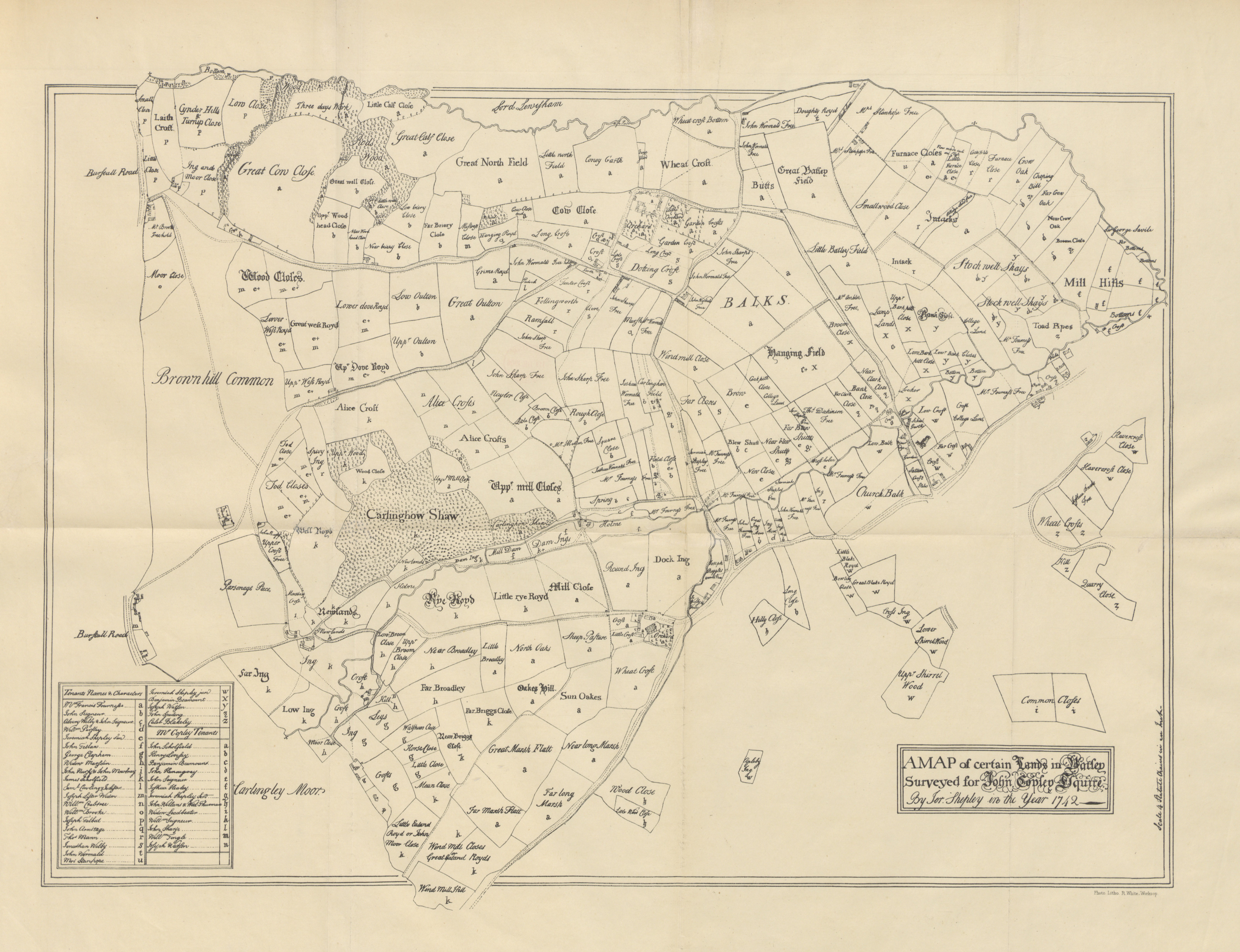
Records of the Parish of Battle 1894
Sussex 1895 Wm Mackenzie
Insurance Plan of Brighton; 1897 sheet 9 (BL 148001) .tiff
Pocket Map Walk Penhurst Edenbridge Hever Domains Sussex c.1900
Plan of Hastings 1910 Wagner and Debets, Leipzig
Bacon's Plan of Brighton 1911
Bexhill 1919 Ward Locke and Co.
.jpg)
.jpg)
(Image%20courtesy%20of%20The%20British%20Library%20King's%20Collection%20Maps%20K.TOP).jpg)
%20.jpg)
.jpg)
.jpg)
%201730%20%20(Image%20courtesy%20of%20The%20British%20Library%20King's%20Collection%20Maps%20K.TOP.42.3.a.f.).jpg)
Thomas%20Badeslade%20and%20William%20Toms%20in%20Chorographia%20Britanniae.html.jpg)
.jpg)
%20.jpg)
%20%20.jpg)
.jpg)
%20.jpg)
.jpg)
.jpg)
%20Leighs'%20New%20Pocket%20Atlas.jpg)
%20%20Robert%20Creighton%20%20for%20Lewis's%20Topographical%20Dictionary.jpg)
%20%20Robert%20Creighton%20%20for%20Lewis's%20Topographical%20Dictionary.jpg)
%201835%20%20Robert%20Creighton%20for%20Lewis's%20Topographical%20Dictionary.jpg)
.jpg)
.jpg)
.jpg)
%20%201850%20Yeakell%20and%20Gardner%20(H)%20.jpg)
.tiff%20.jpg)
.tiff%20.jpg)