| |
Home Resources consulted for Yorkshire A Bibliography of County Maps - Large Scale County Maps of England. Tooley R.V. The Printed Maps in the Atlases of Great Britain and Ireland1579-1870 Chubb Thomas Dawson 1927 |
To resize image:
L-click on image or hold CTRL and use mouse scroll-wheel |
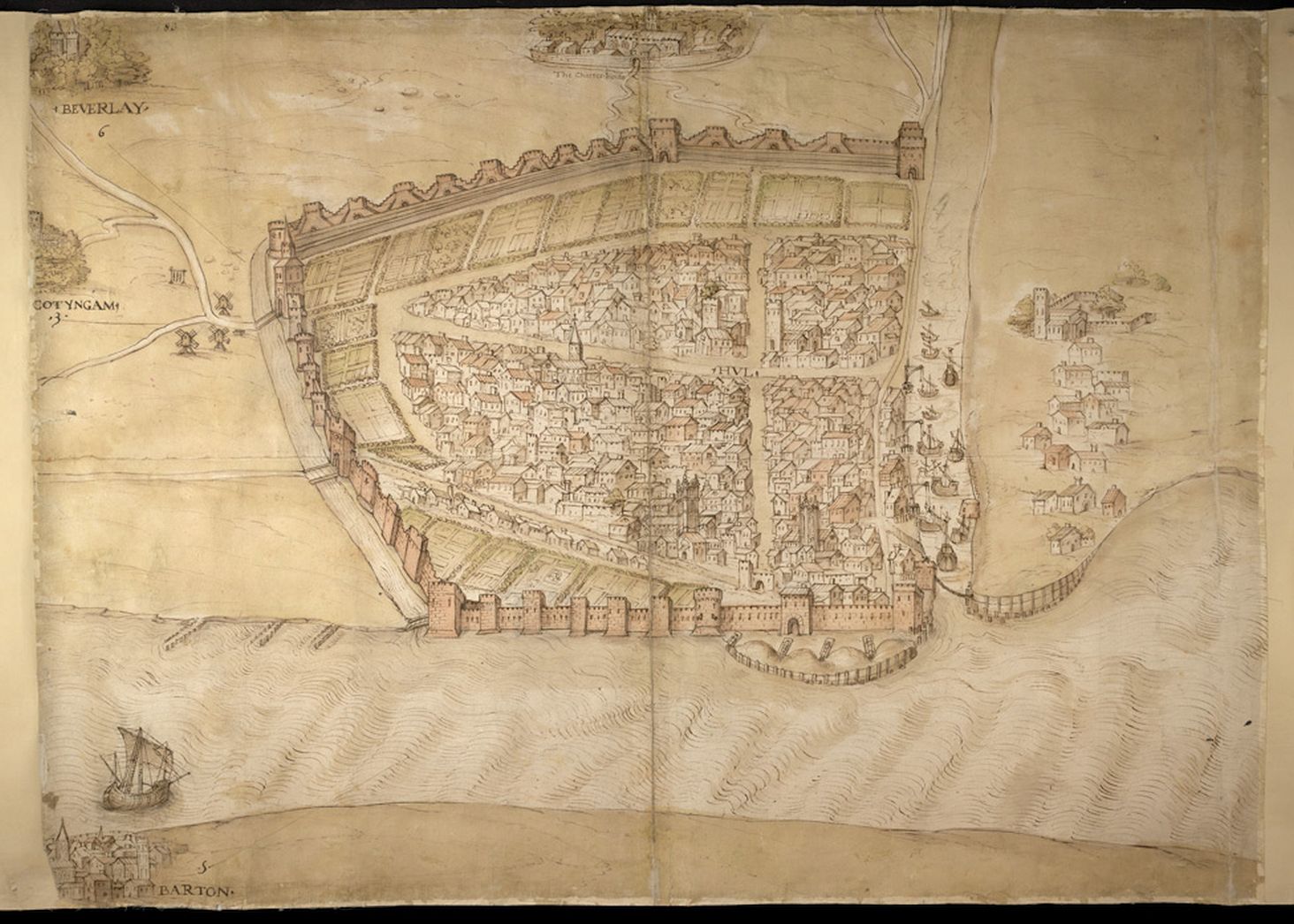
Plan of Hull 1537 anon.
West Riding of Yorkshire 1610 John Speed in The Theatre of the Empire of Great Britaine (Chubb p.23. XXII)
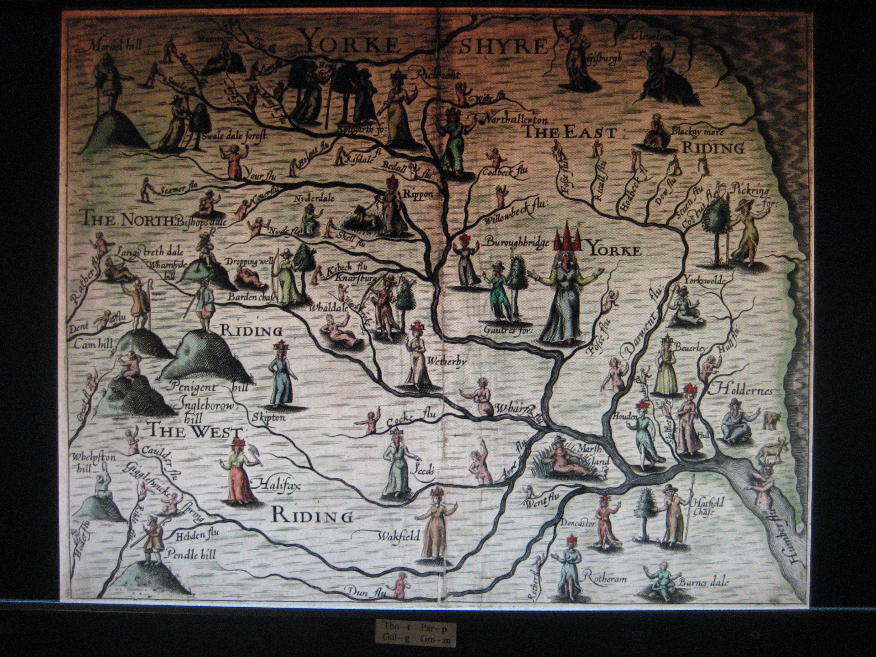
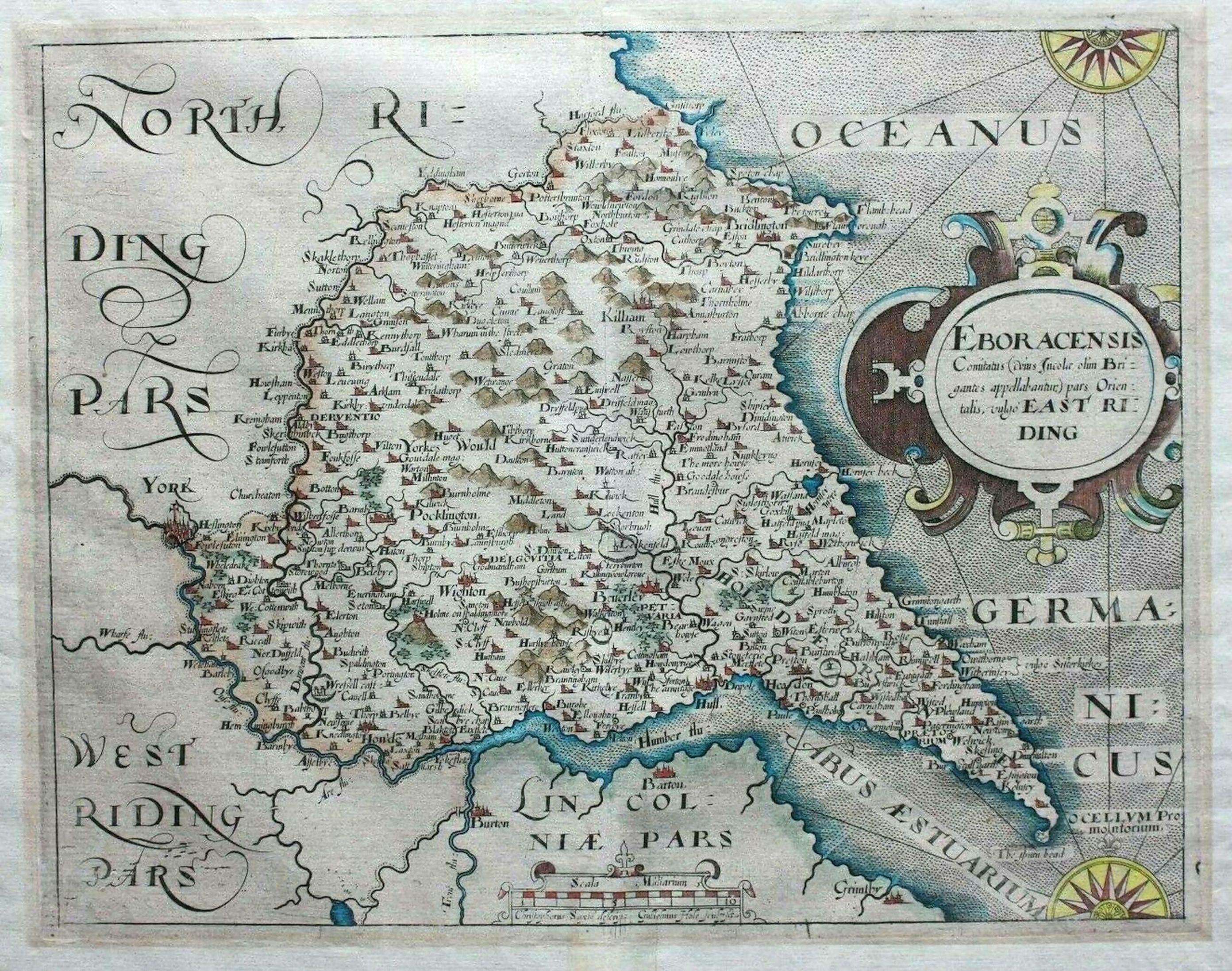
Yorkshire 1612 Michael Drayton to illustrate his Polyolbion (Chubb p.45 XXXIII)East Riding of Yorkshire 1607 Christopher Saxton Updated and Reissued by William Hole (Chubb p.32 XVIII )
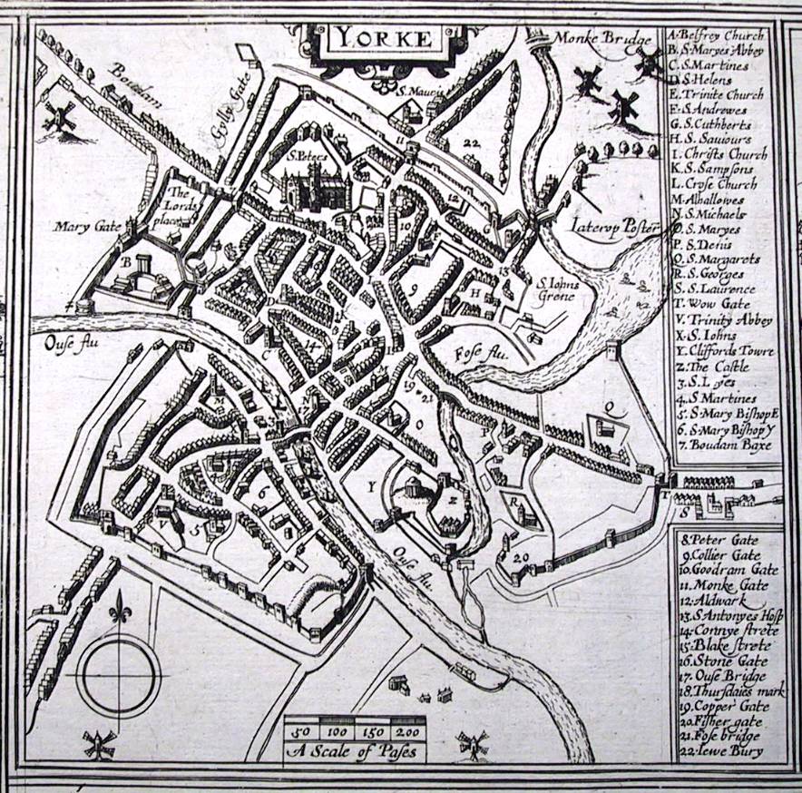
Yorke 1617 Georg Braun and Remegius Hogenberg
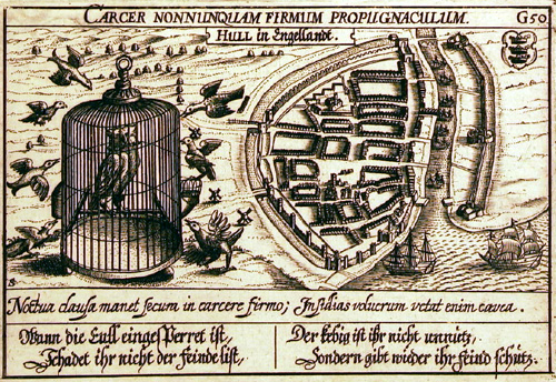
Hull 1620 Daniel Meisner
Yorkshire 1626 John Bill in his Abridgement of Camden's Britannia (Chubb p.52 XLI )
Yorkshire Lincolnshire Staffordshire Nottinghamshire Leicestershire Rutland and Norfolk 1628 Gerard Mercator
A True & Perfect Platt of Every Particular Cavel of Closs ...etc. 1639 Josias Arelbout & Thomas Smith Marriner
Yorkshire Lincolnshire: Staffordshire: Nottinghamshire: Leicestershire: Rutland: and Norfolk 1636 Henrik Hondius after Gerard Mercator
(Image courtesy of The British Library King's Collection)
Plan of Kingston upon Hull 1640 Wenceslaus Hollar
Yorkshire 1646 Jan Jansson for his Atlas Novus
Yorkshire North Riding 1646 Jan Jansson for his Atlas Novus
East Riding of Yorkshire 1646 Jan Jansson (Image courtesy of Harvard University Library)
Yorkshire 1646 Jan Jansson in his Atlas Novus
Yorkshire 1646 Dirck Lansz van Santen in the Atlas Van der Hagen held in the collections of the Koninklijke Bibliotheek Atlas (Image courtesy of Wikimedia)
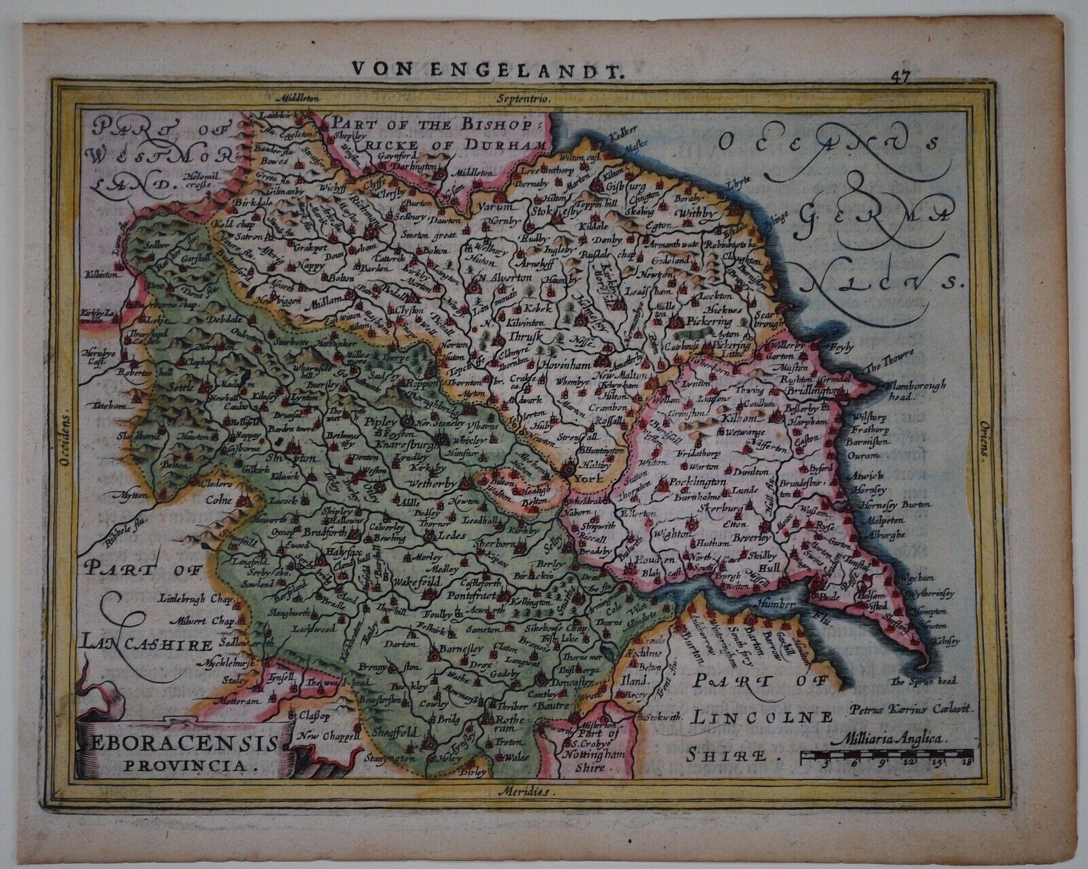
Yorkshire 1651 Gerard Mercator in his Von Engeland
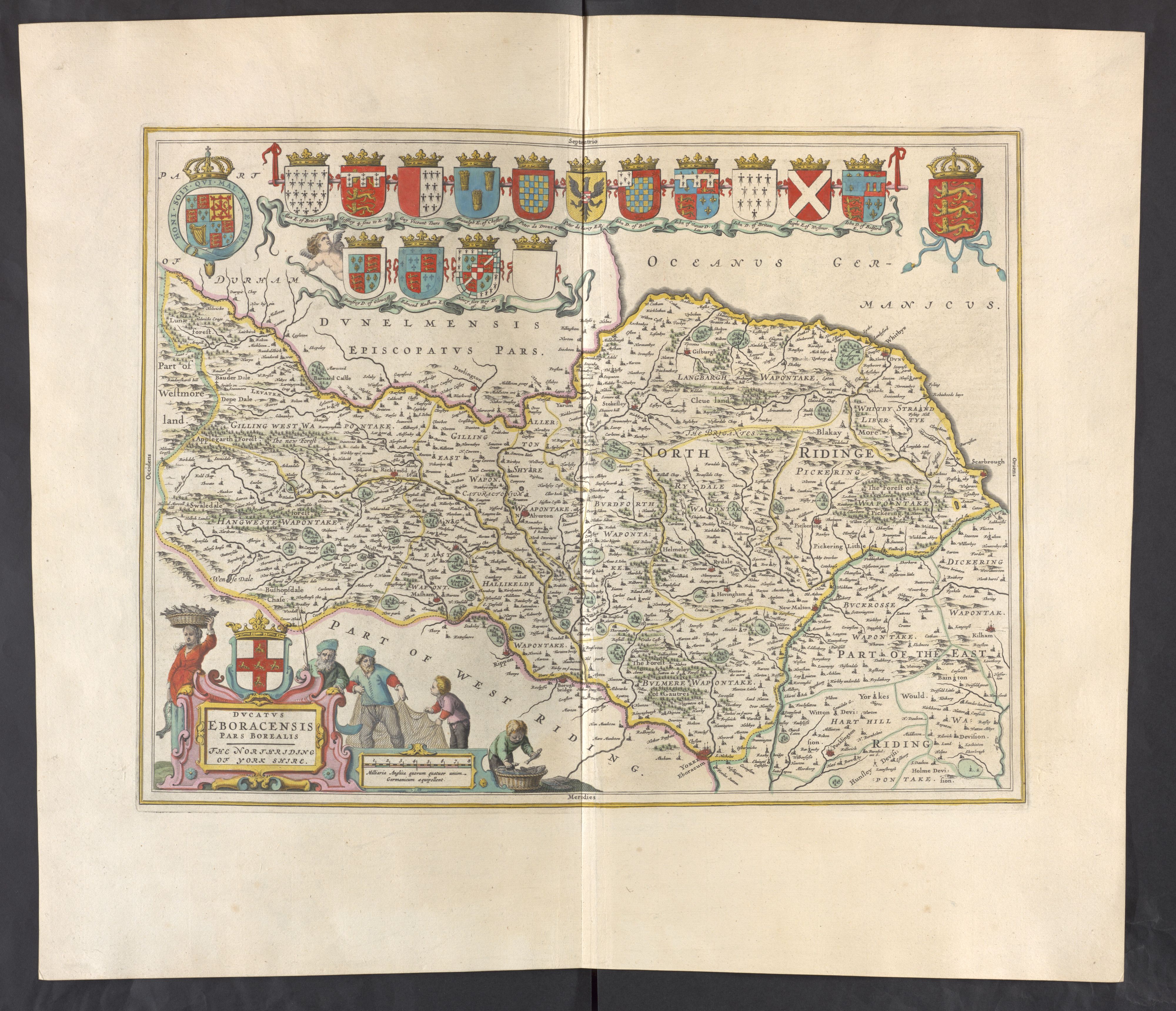
Yorkshire North Riding 1659 Joan Blaeu Atlas Major (Chubb 0.62 LIX )
(Image courtesy of Wikimedia)
Newe Castle Novecastrum 1660 ( Amsterdam, anon. after John Speed(1610) (Image courtesy of The British Library Maps K.TOP.32.50
Yorkshire 1662 John Speed in A Prospect of the Most Famous Parts of the VVorld (Roger Rea Edition)
Yorkshire North and East Ridings 1662 John Speed in A Prospect of the Most Famous Parts of the World (Roger Rea Edition)
(Image courtesy of The British Library King's Collection)
Yorkshire West Riding 1662 John Speed in A Prospect of the Most Famous Parts of the World (Roger Rea Edition)
(Image courtesy of The British Library King's Collection)
West Riding of Yorkshire 1665 Joan Blaeu in his Grand Atlas (Chubb 0.62 LIX )
Yorkshire East Riding 1665 Joan Blaeu (image courtesy of British Library - Albums) (Chubb 0.62 LIX )
(image courtesy of British Library - Albums)
Yorkshire East Riding 1673 Richard Blome in his Britannia (Chubb p.81 XCIX )
Yorkshire 1676 Playing Card: Robert Morden
The East Riding of Yorkshire 1690 Robert Morden (Chubb CXlll )(Image courtesy of Yale University Library)
The West Riding of Yorkshire 1690 Robert Morden (Chubb CXll) (Image courtesy of Yale University Library)North Riding of Yorkshire 1695 Robert Morden for Camden's Britannia (Chubb CXlll )
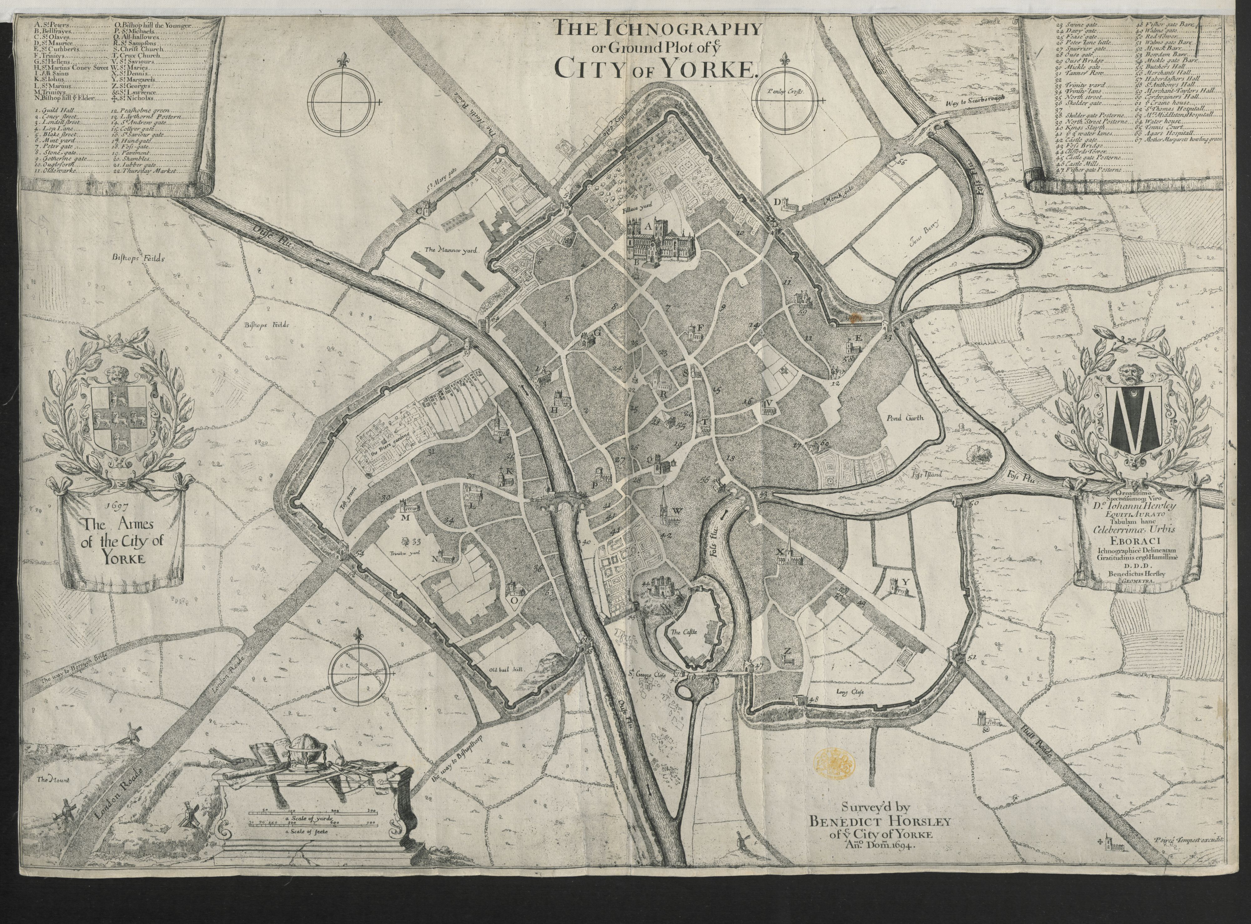
The Ichnography or Ground Plot of ye City of Yorke 1694 Benedict Horesley. (Image courtesy of The British Library King's Collection Maps K.TOP.45.1
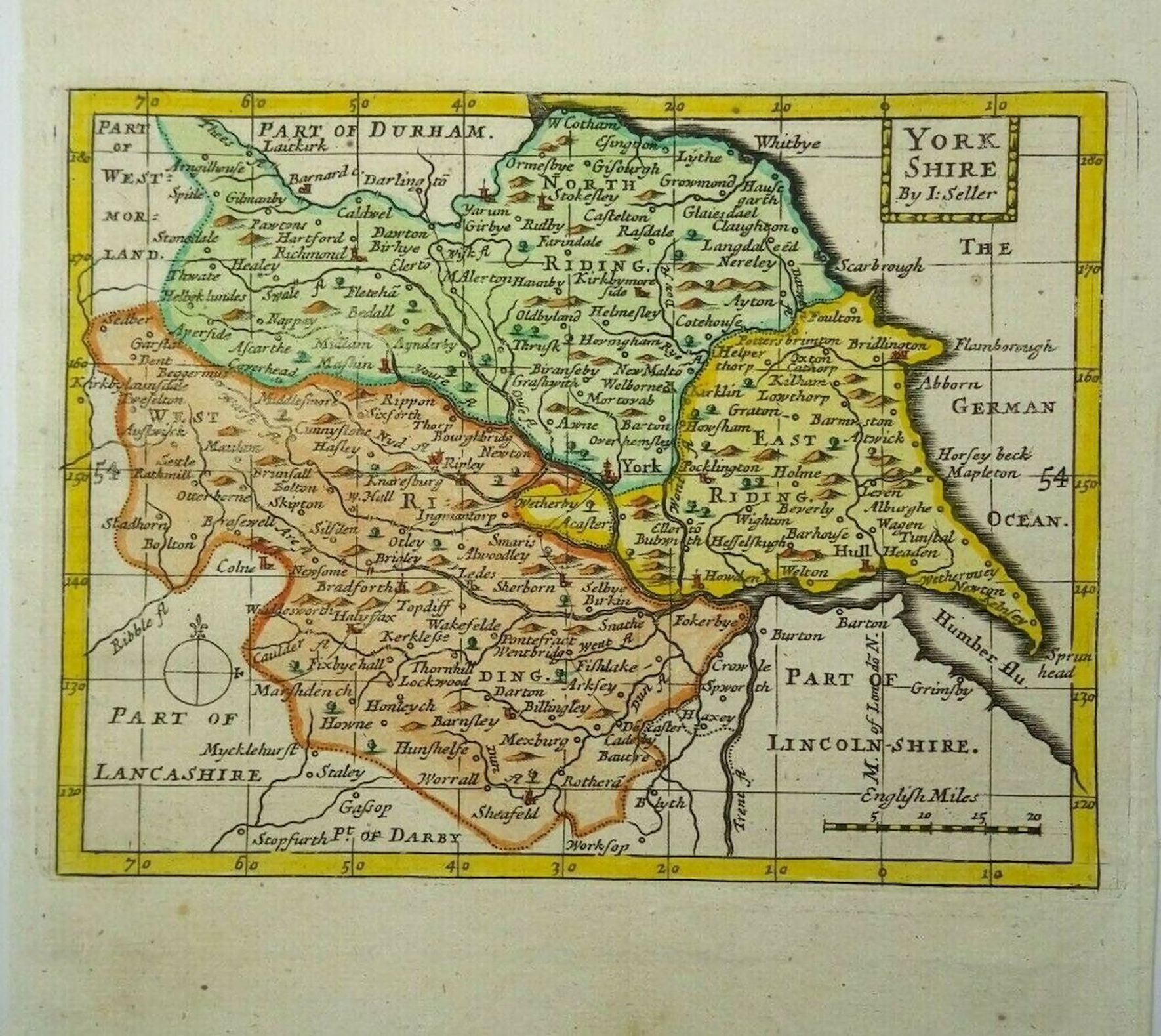
Yorkshire 1701 1701-1703 John Seller for Camden's Britannia Abridged or: using the same plates; The History of England or: also: Anglia and Contracta. and finally (post mortem) for Francis Grose's Antiquities of England and Wales 1777 -87 Chubb p.100 CXXII)
North Riding of Yorkshire 1715 Gerardum Valk & Petrum Shenk after Jan Jansson: Engraved Wenceslaus Hollar
(Image Courtesy of Manchester University Library) (Chubb p.77 XCIV)
The Eastriding of Yorke shire 1715 Gerardum Valk & Petrum Shenk after Jan Jansson's Atlas Contractus. Engraved Wenceslaus Hollar. Shenk and Valk purchased Jansson's plates after his death and re-published them as single sheets. (Image Courtesy of Manchester University Library) (Chubb p.77 XCIV)
(Image courtesy of Wikimedia)
Richmond 1720 J. Warburton
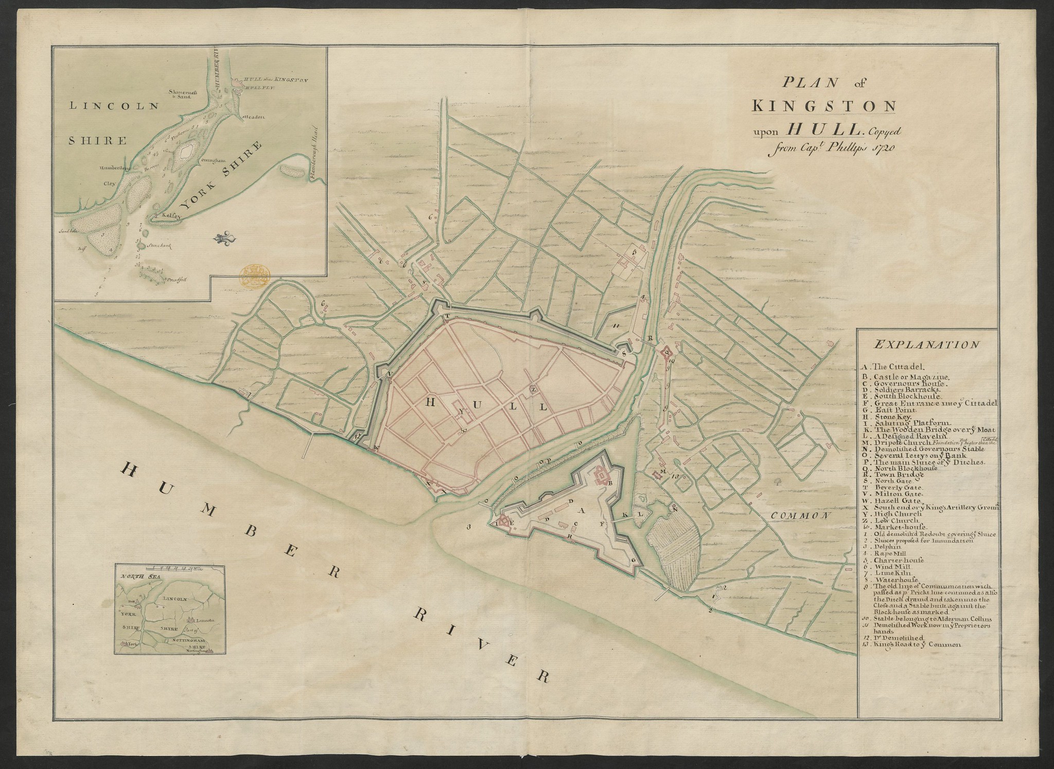
Kingston upon Hull 1720 "Copyed from Capt.Phillips"
(Image courtesy of The British Library King's Collection Maps K.TOP.44.33.a.)
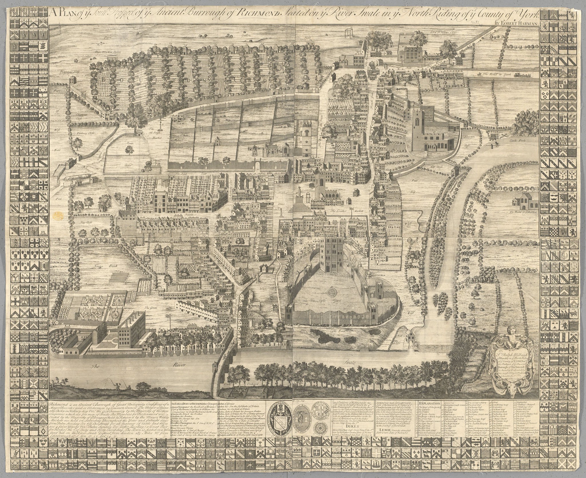
South Prospect Of Richmond. In Ye North Riding Of York 1724 Robert Harman (filed in error at BL as R.Cole)
(Image courtesy of The British Library King's Collection Maps K.TOP.44.44. ).
Yorkshire East Riding 1725 Herman Moll in A New description of England and Wales
(Image courtesy of The British Library King's Collection Maps K.TOP.44.11)
Yorkshire North Riding 1725 Herman Moll in A New description of England and Wales
(Image courtesy of The British Library King's Collection Maps K.TOP.44.11.)
Richmondiae Comitatus et Alvertunae Schira 1733 R. Gosling
(Image courtesy of The British Library King's Collection Maps K.TOP.44.20.1.)
Kingston upon Hull 1735 George Ohlson (reprint 1869)
(Image courtesy of The British Library King's Collection)
East Riding of Yorkshire 1724 Herman Moll in A New description of England and Wales (Chubb p.125 CLX
The North Riding of Yorkshire 1724 Herman Moll in A New Description of England and Wales (Chubb p.125 CLX
West Riding of Yorkshire 1724 Herman Moll in A New Description of England and Wales (Chubb p.125 CLX
Yorkshire 1724 Herman Moll in A New Description of England and Wales (Chubb p.125 CLX)
Kingston-upon-Hull 1725 anon.
Plan of the town of Leeds 1725 John Cossins
Yorkshire 1728 Phillip Overton and Thomas Bowles (A close copy of John Warburton?s large scale map of Yorkshire.)
Yorkshire 1732 Phillip Lea after Christopher Saxton sold by George Wildey
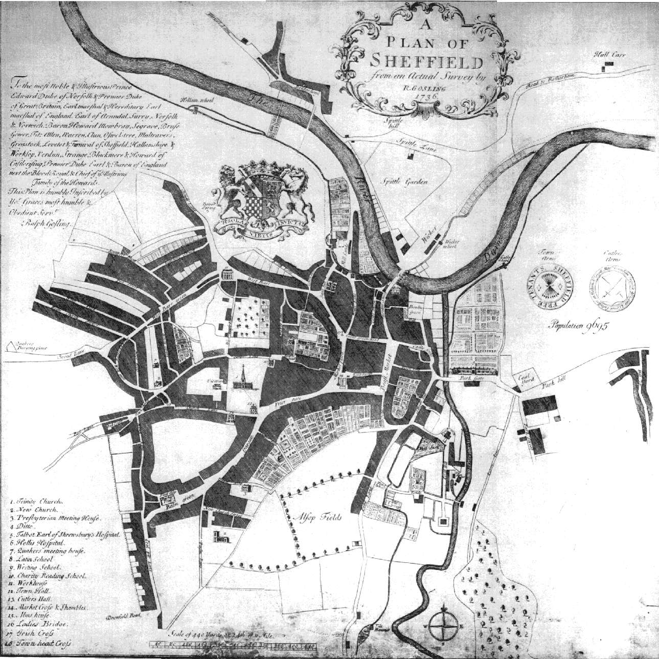
Sheffield (Sheet 01) 1736 Gosling
Sheffield (Sheet 02) 1736 Gosling
A Plan of the City of York 1736 William Bowyer
(Image courtesy of The British Library King's Collection Maps K.TOP.45.2.
Yorkshire 1742 Thomas Badeslade and William Tomsin Chorographia Britanniae (Chubb p.135 CLXXIIV
Yorkshire 1744 J. Cowley in Robert Dodsley's Geography of England (Chubb p.139 CLXXXI)
A Plan of Newcastle upon Tyne 1746 Isaac Thompson (Image courtesy of The British Library: King's Collection)
A New and Exact plan of the city of York 1748 John Cossins
(Image courtesy of The British Library King's Collection Maps K.TOP.45.3.)
Plan de la Ville et Soubourgs de York 1750 Sr. P. Chassereau engr. Jean Lerocque
(Image courtesy of The British Library King's Collection Maps K.TOP.45.4.
The East Riding of York Shire 1750 Emanuel Bowen .and Thomas Kitchen in The Large English Atlas J.Hinton pub Chubb p.157 CXCV) (Image courtesy of Yale University Library)
An Accurate Map of the North Riding of York Shire 1750 Emanuel Bowen for The Large English Atlas
The West Riding of York Shire1750 Emanuel Bowen and Thomas Kitchin J.Hinton pub. (Image courtesy of Yale University)
A Plan of Newcastle 1769 A. Armstrong (Image courtesy of The British Library King's Collection)
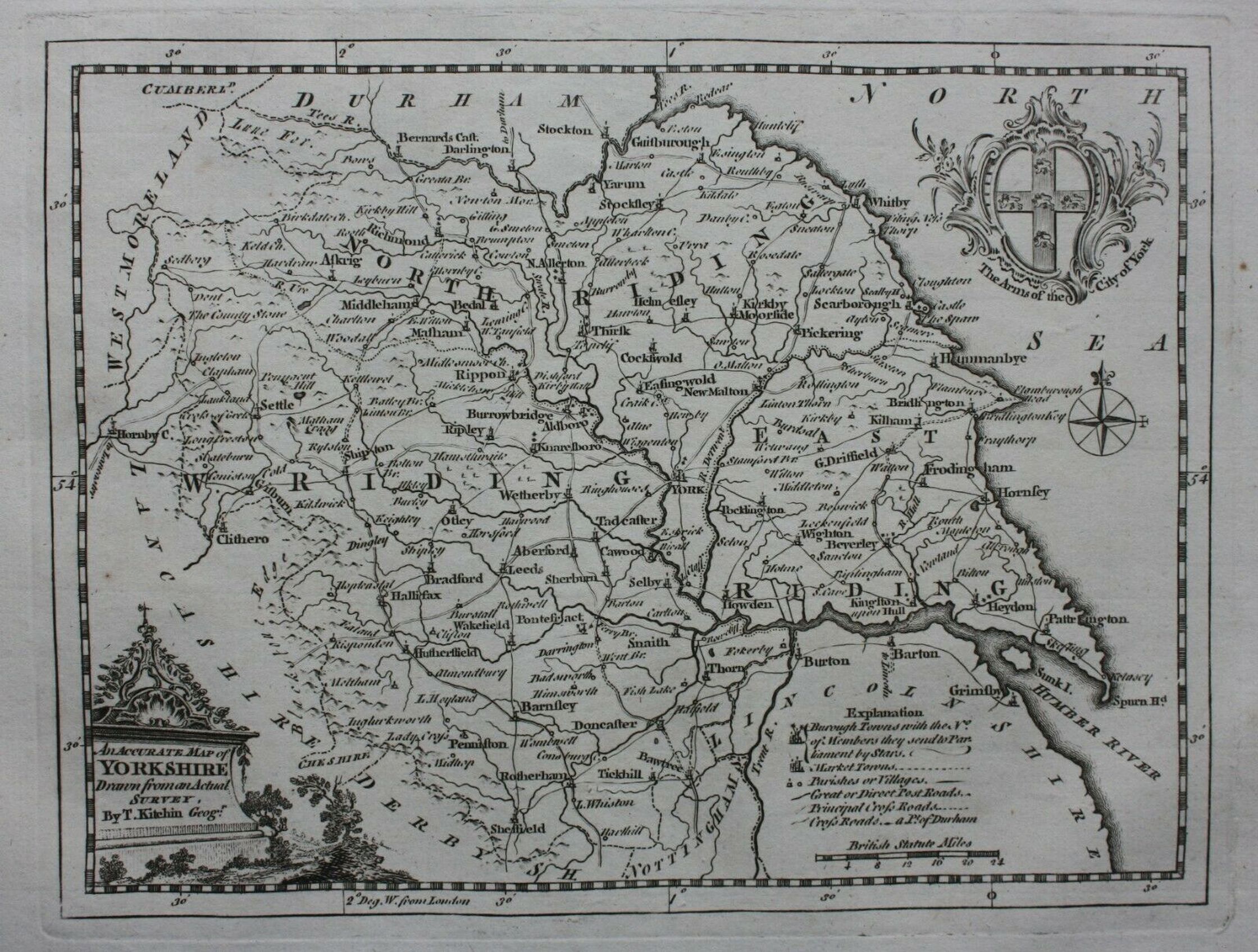
Yorkshire 1769 Thomas Kitchin in Kitchin's Pocket Atlas (Chubb p.195CCXXXV)
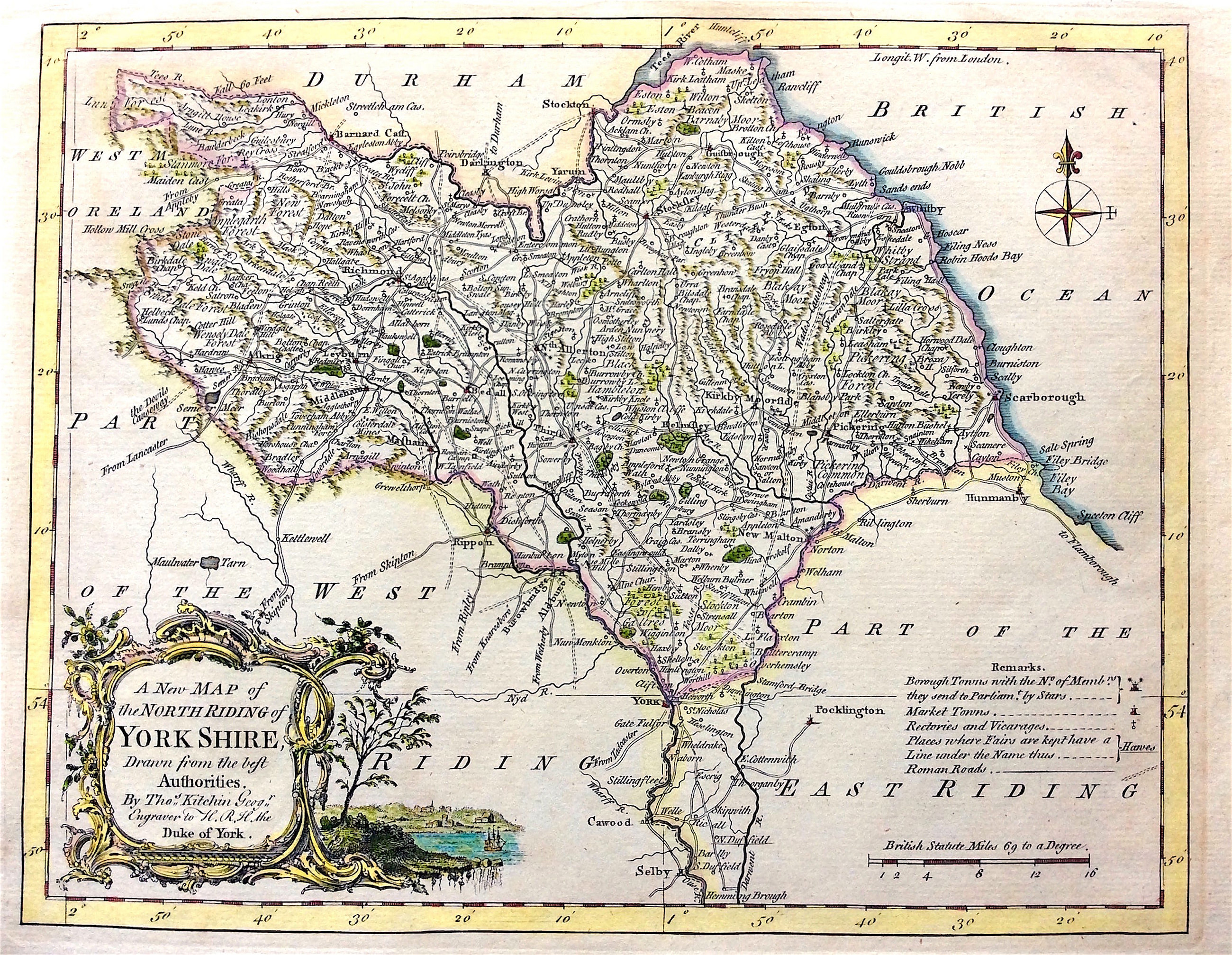
The North Riding of Yorkshire 1770 Thomas Kitchin
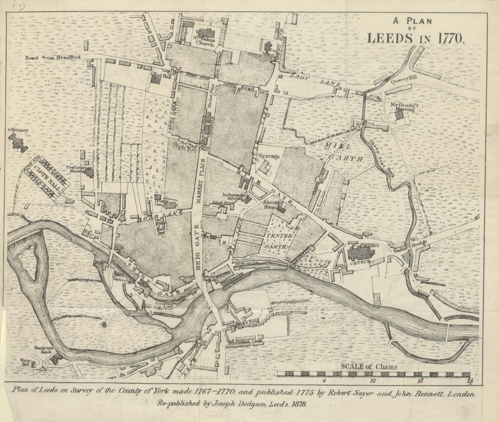
Leeds 1770 Robert Sayer (re-published 1878 )
The County of York Survey'd 1770 Thomas Jeffereys
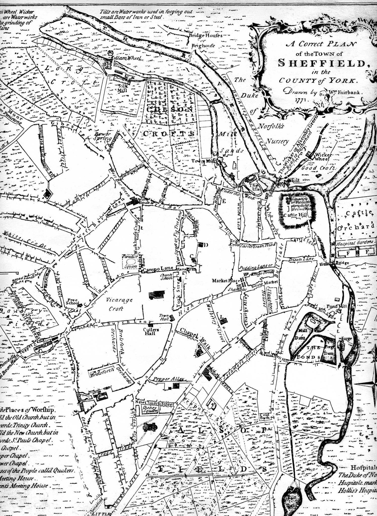
Sheffield 1771 William Fairbanks
Yorkshire East Riding 1772 Sidney Hall for Leigh's New Atlas of England and Wales (Chubb 272 CCCXXIII)
A Plan of the Town of Warrington 1773
(Image courtesy of The British Library: King's Collection. Maps K.Top.18.85.11 tab. .
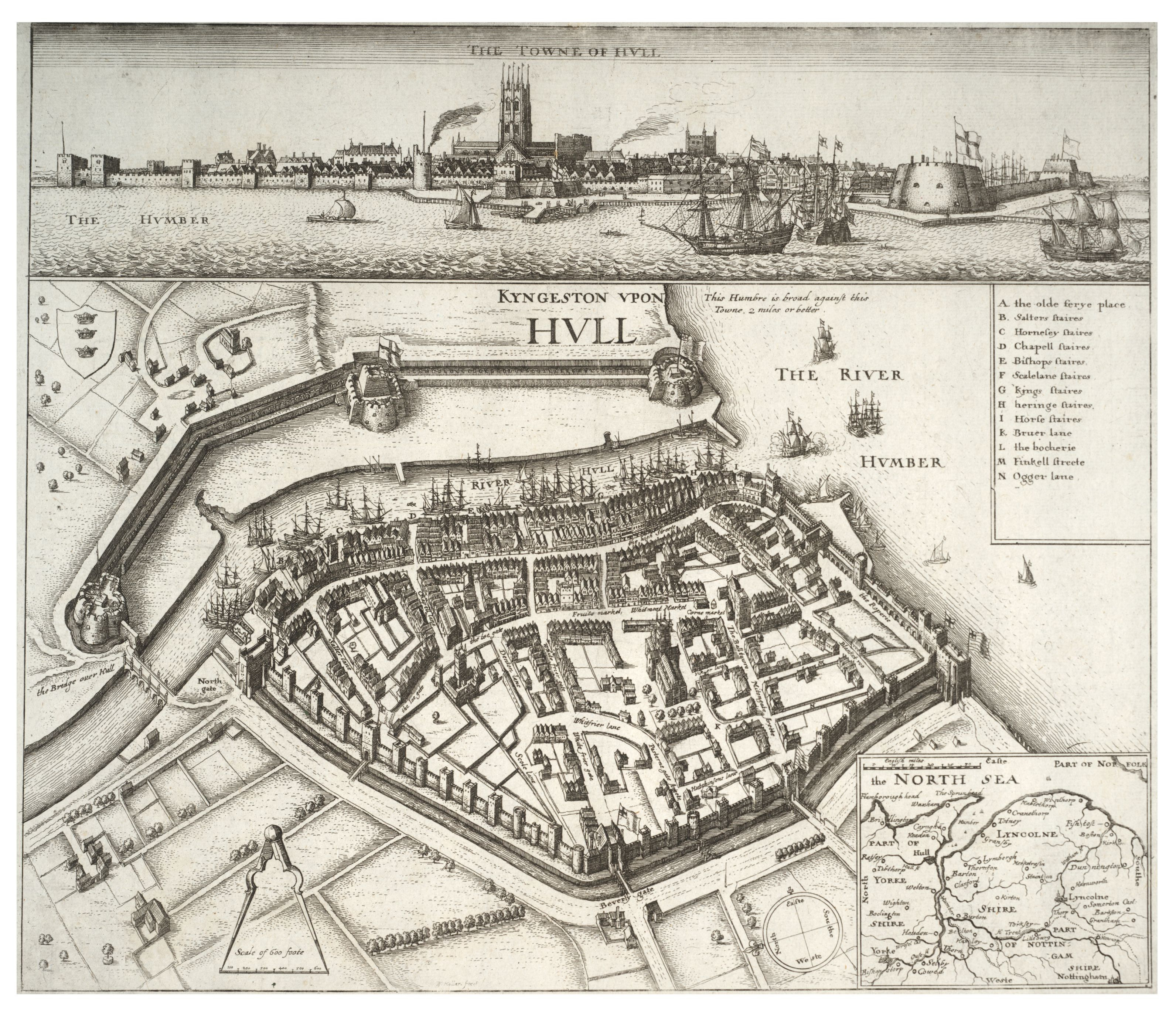
The Towne of Hull 1775 Wenceslas Hollar
Plan of the City of York and Ainsty 1785 James Thomson (Image courtesy of
The British Library King's Collection Maps K.TOP.44.19.)
Yorkshire 1786 Thomas Kitchen in The Antiquities of England and Wales
Yorkshire 1787 John Seller in his Anglia Contracta
A Plan of Newcastle upon Tyne and Gateshead 1788 R. Beilby
(Image courtesy of The British Library: King's Collection)
Yorkshire 1790 Westmoreland Northumberland Franz Johann Joseph Von-Reilly
Plan of the Town and Harbour of Kingston upon Hull 1790 A. Bower
(Image courtesy of The British Library King's Collection)
North Riding of York Shire 1790 Emanuel Bowen (Image courtesy of Yale University Library)
Kingston-upon-Hull 1792 A. Bower
Yorkshire 1793 John Cary in his New and Correct English Atlas Chubb p.213 CCLX)
(Image courtesy of New York Library Digital Collections
East Riding of Yorkshire 1793 John Cary in his New and Correct English Atlas Chubb p.213 CCLX)
(Image courtesy of New York Library Digital CollectionsNorth Riding of Yorkshire 1793 John Cary in his New and Correct English Atlas Chubb p.213 CCLX)
(Image courtesy of New York Library Digital Collections)
The Canal from Liverpool to Leeds 1794 John Aikin & John Stockdale
Yorkshire and Lincolnshire Canal 1794 John Cary
The Canal from Huddersfield to Ashton 1795 John Aikin
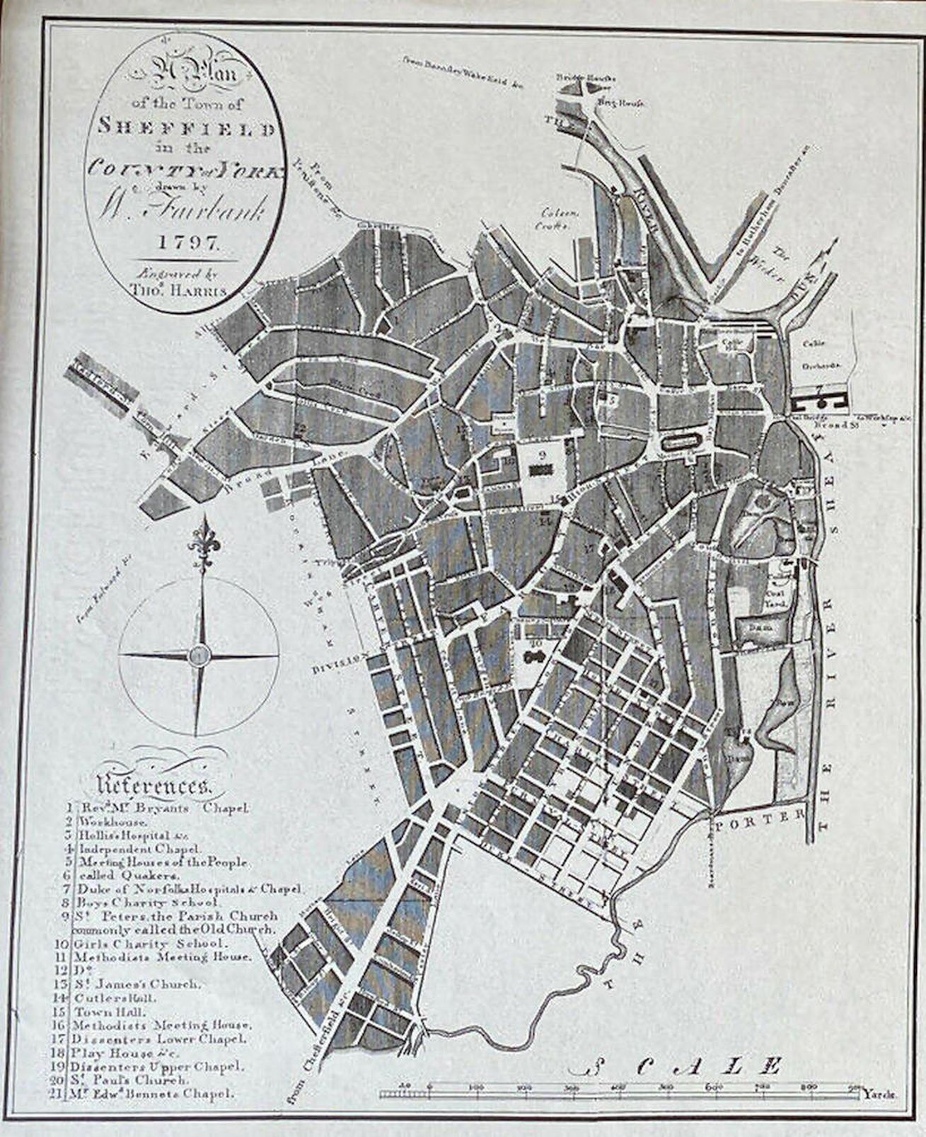
A Plan of Sheffield 1797 William Fairbank
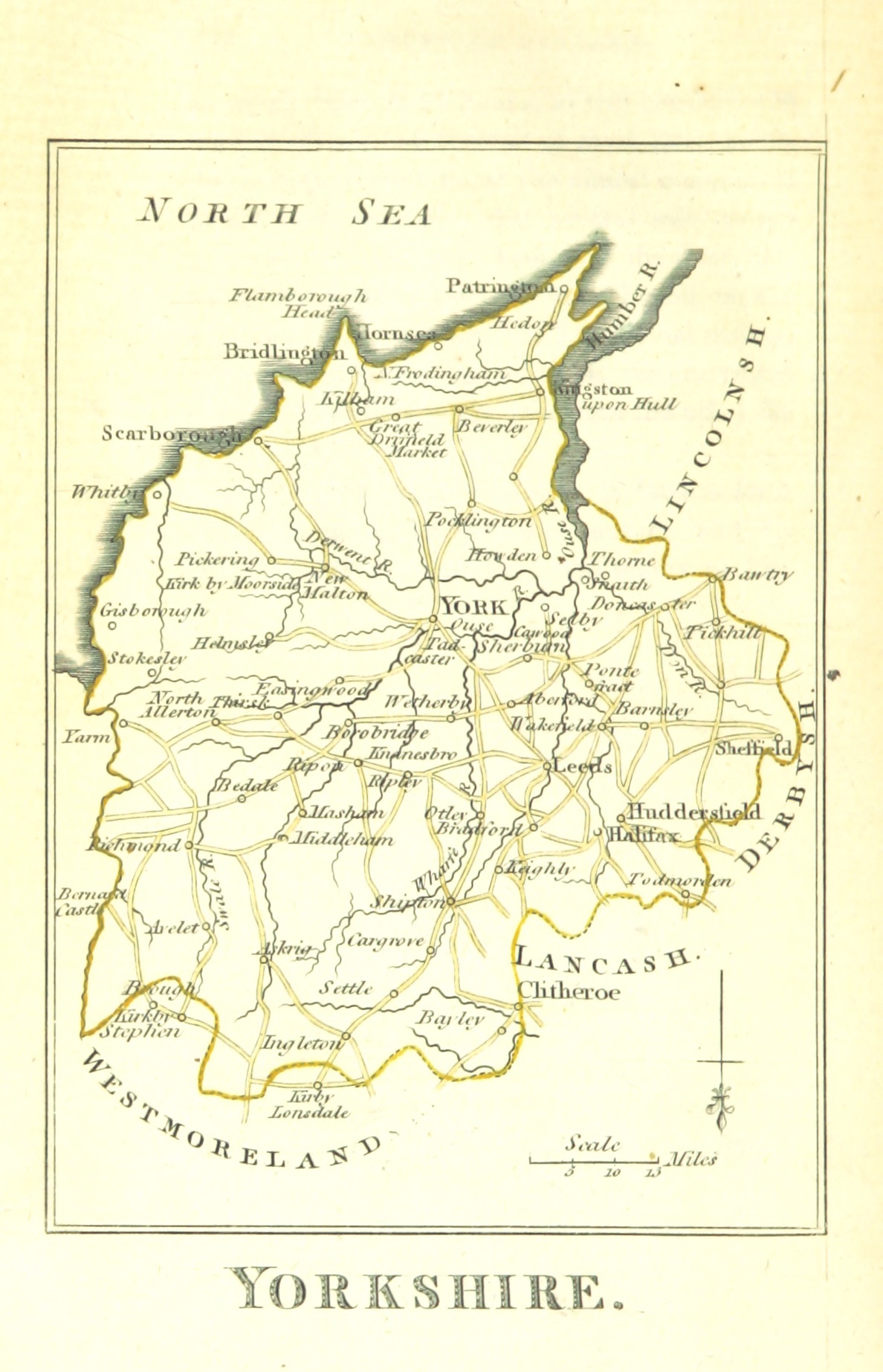
Yorkshire 1804 William Green in The Picture of England
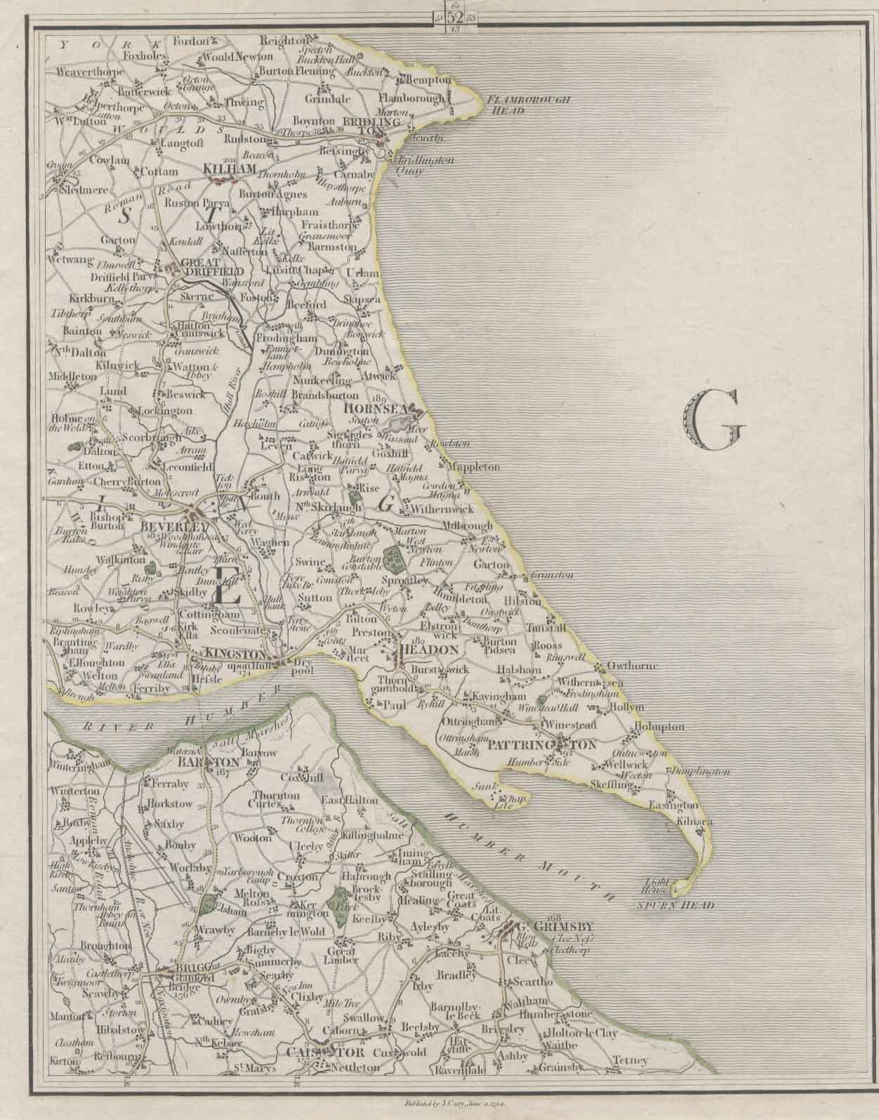
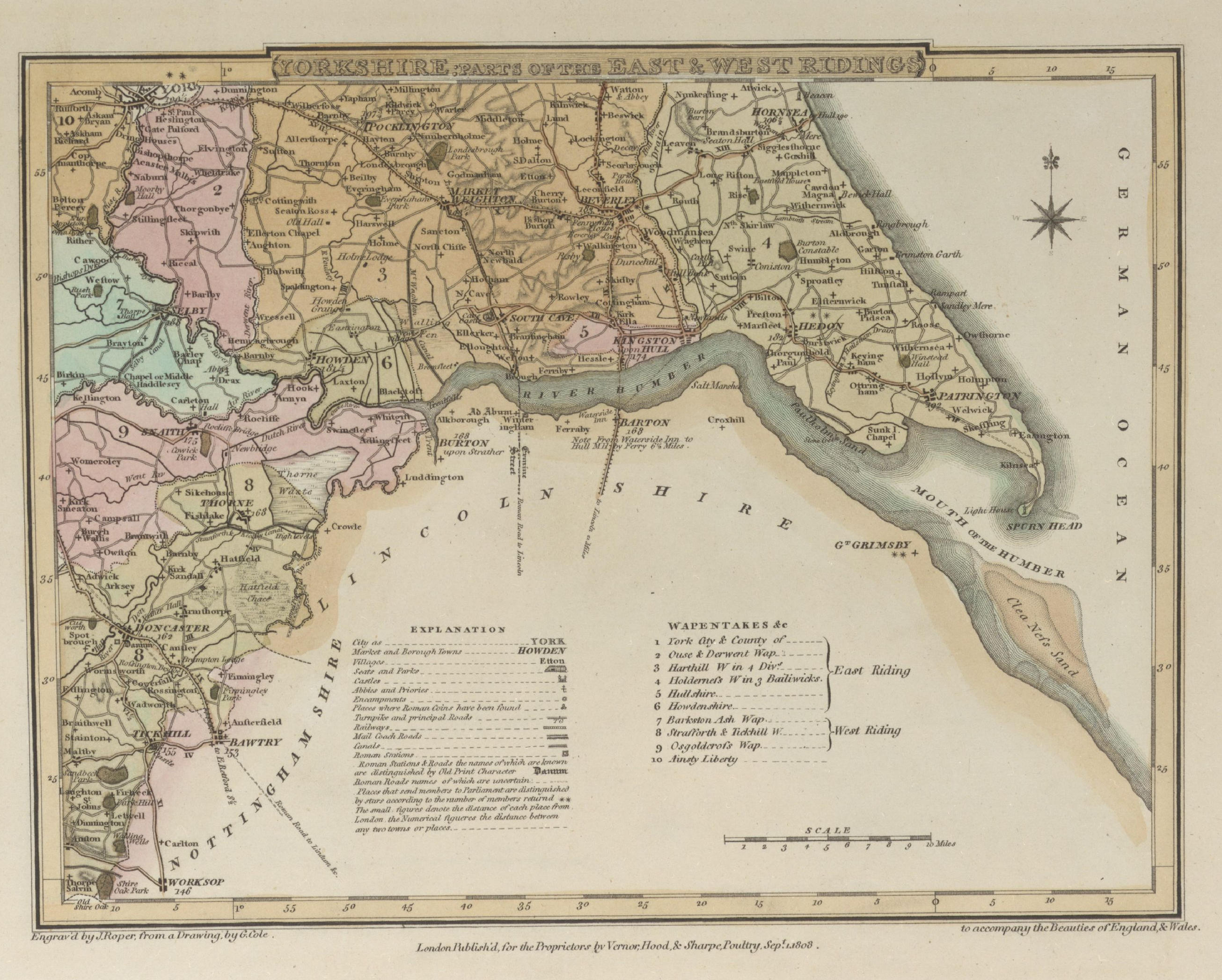
(Image courtesy of The British Library: King's Collection)Yorkshire East and West Riding 1810 George Cole and John Roper in their British Atlas
p.250 CCCXXXIX)
(Image courtesy of The British Library-King's Topographical Collection)
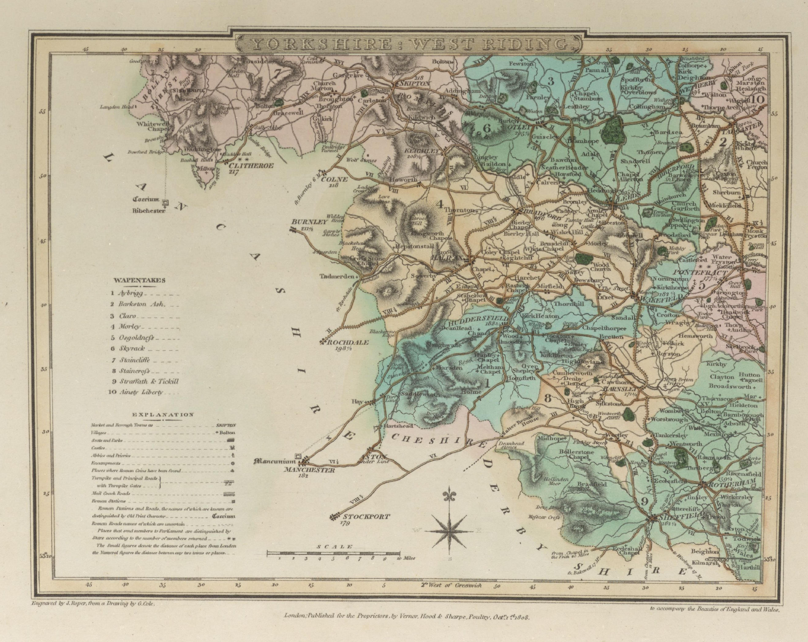
Yorkshire West Riding 1810 George Cole and John Roper in their British Atlas (Chubb p.250 CCCXXXIX)
(Image courtesy of The British Library-King's Topographical Collection)
North Riding of Yorkshire 1819 Ellis's New and Correct Atlas (Chubb p.266 CCCLXIII)
West Riding of Yorkshire 1819 Ellis's New and Correct Atlas (Chubb p.266 CCCLXIII)
Yorkshire 1820 Sidney Hall for Leigh's New Atlas of England and Wales (Chubb p.272CCCLXXIV )
A Topographical Dictionary of Yorkshire 1822 Thomas Langdale (Image courtesy of The British Library-Mechanical Curator)
Yorkshire 1822 Samuel Leigh in Leigh's New Pocket Atlas
A Plan of Sheffield 1823 anon.
Plan of Hull 1823 Samuel Neele
Yorkshire1824 George Carrington Gray in The Tourist and Traveller's Guide to the Roads.
(Chubb p.281 CCCXCII)Yorkshire East Riding 1824 George Carrington Gray in The Tourist and Traveller's Guide to the Roads.
(Chubb p.281 CCCXCII)Yorkshire 1828 Samuel Lewis for The Encyclopaedia Londoniensis
Yorkshire 1830 Pigot & Co.'s British Atlas
Beverly 1832 Robert Kearsley Dawson for Plans of the Cities and Boroughs of England and Wales
Greenwood's Picture of Hull 1835 J. & C. Greenwood (Image courtesy of The British Library King's Collection)(Image courtesy of The British Library King's Collection)
Yorkshire East Riding 1834 C. and J. Greenwood in Atlas of the Counties of England (Chubb CCCCLVII1a) (Image courtesy of www.davidrumsey.com)
Yorkshire North Riding 1834 C. and J. Greenwood in Atlas of the Counties of England (Chubb CCCCLVII1a) (Image courtesy of www.davidrumsey.com)
Yorkshire West Riding 1834 C. and J. Greenwood in Atlas of the Counties of England (Chubb CCCCLVII1a) (Image courtesy of www.davidrumsey.com)
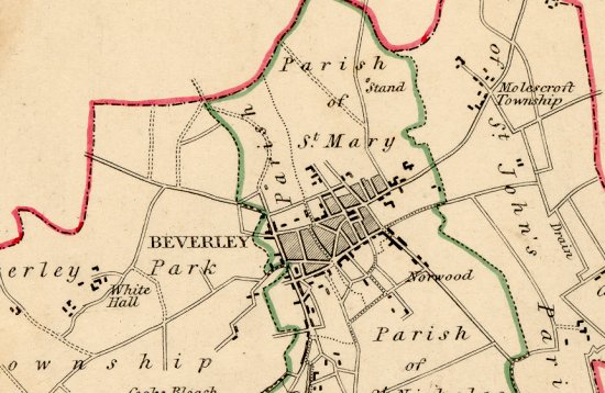
Beverley 1835 Robert Creighton for Lewis's Topographical Dictionary
(Chubb p.322 CCCCLXIV)
Bradford 1835 Robert Creighton for Lewis's Topographical Dictionary (Chubb p.322 CCCCLXIV)Dudley 1835 Robert Creighton for Lewis's Topographical Dictionary (Chubb p.322 CCCCLXIV)
Huddersfield 1835 Robert Creighton for Lewis's Topographical Dictionary (Chubb p.322 CCCCLXIV)
Grimsby 1835 Robert Creighton for Lewis's Topographical Dictionary (Chubb p.322 CCCCLXIV)
Knaresborough 1835 Robert Creighton for Lewis's Topographical Dictionary (Chubb p.322 CCCCLXIV)
New Malton 1835 Robert Creighton for Lewis's Topographical Dictionary (Chubb p.322 CCCCLXIV)
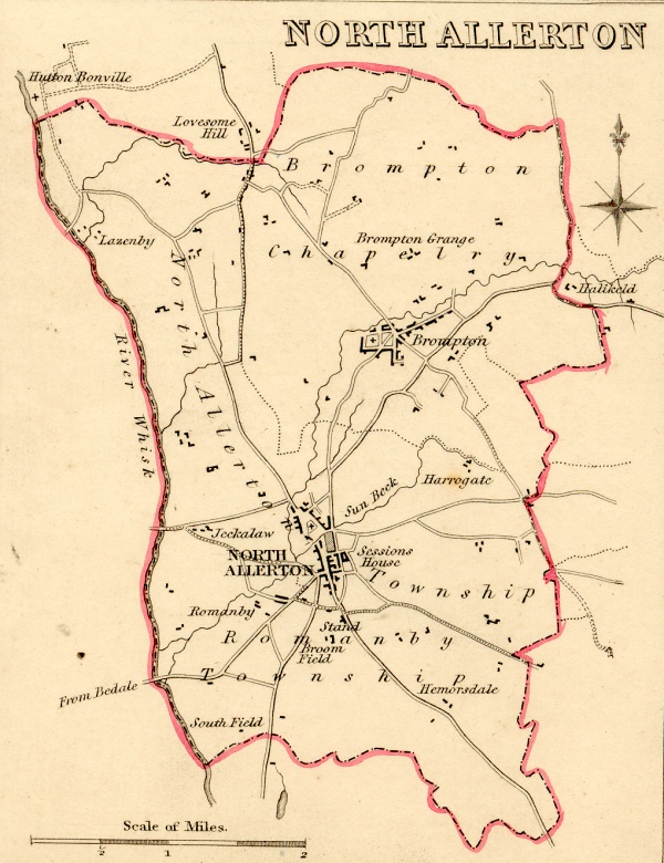
Northallerton 1835 Robert Creighton for Lewis's Topographical Dictionary Scroll down for detail...
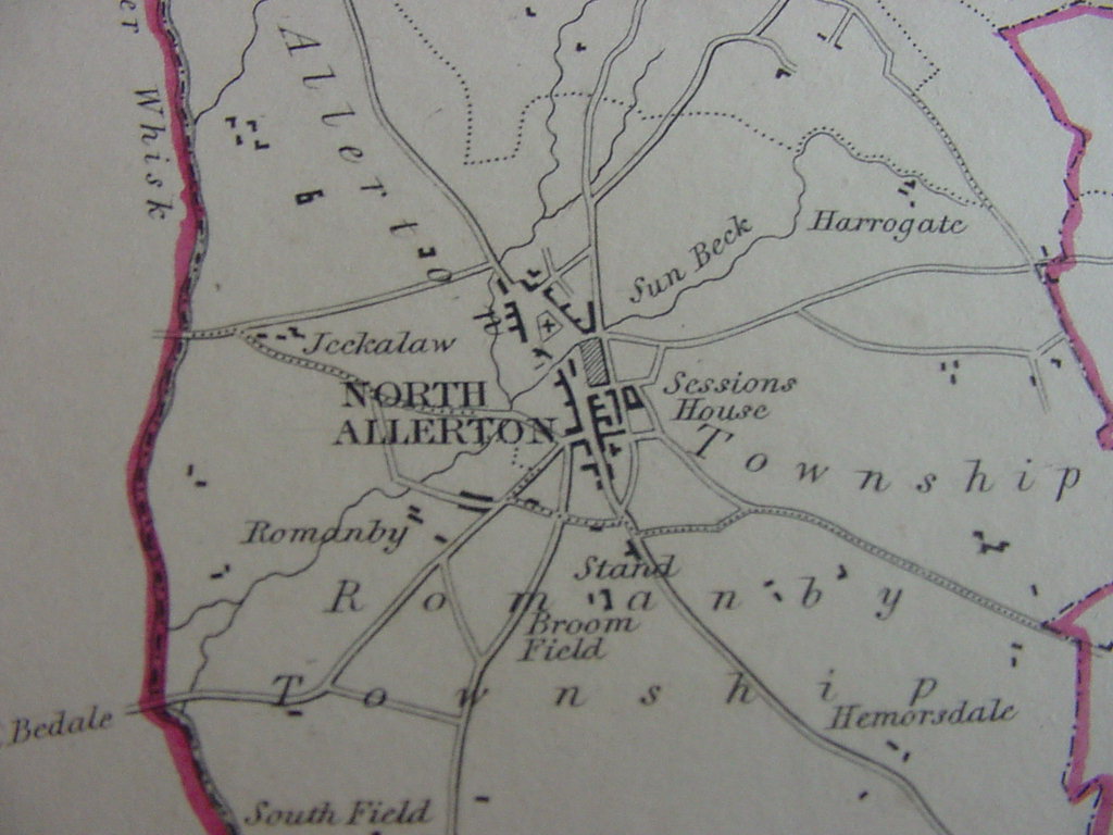
Northallerton-detail 1835 Robert Creighton for Lewis's Topographical Dictionary
Pontefract 1835 Robert Creighton for Lewis's Topographical Dictionary (Chubb p.322 CCCCLXIV)
Richmond 1835 Robert Creighton for Lewis's Topographical Dictionary (Chubb p.322 CCCCLXIV)
Ripon 1835 Robert Creighton for Lewis's Topographical Dictionary (Chubb p.322 CCCCLXIV)Scarborough 1835 Robert Creighton for Lewis's Topographical Dictionary (Chubb p.322 CCCCLXIV)
Thirsk 1835 Robert Creighton for Lewis's Topographical Dictionary (Chubb p.322 CCCCLXIV)
Whitby 1835 Robert Creighton for Lewis's Topographical Dictionary (Chubb p.322 CCCCLXIV)
York 1835 Robert Creighton for Lewis's Topographical Dictionary
(Chubb p.322 CCCCLXIV)Northallerton 1835 Robert Kearsley Dawson for the Boundaries Commission
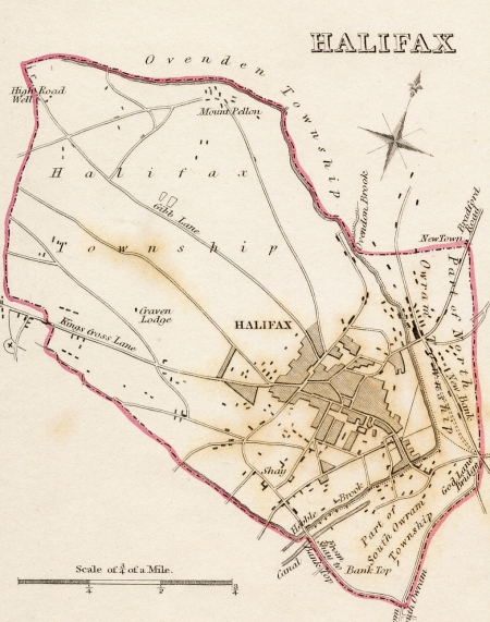
Northallerton-Detail 1835 Robert K. Dawson for the Boundaries CommissionHalifax 1835 Robert K. Dawson for the Boundaries Commission
East Riding of Yorkshire 1836 Thomas Moule in The English Counties Delineated (Chubb p.325 CCCLXXI)
West Riding of Yorkshire 1836 Thomas Moule in The English Counties Delineated ( Chubb p.325 CCCLXXI)
North Riding of Yorkshire 1836 Thomas Moule in The English Counties Delineated (Chubb p.325 CCCLXXI)
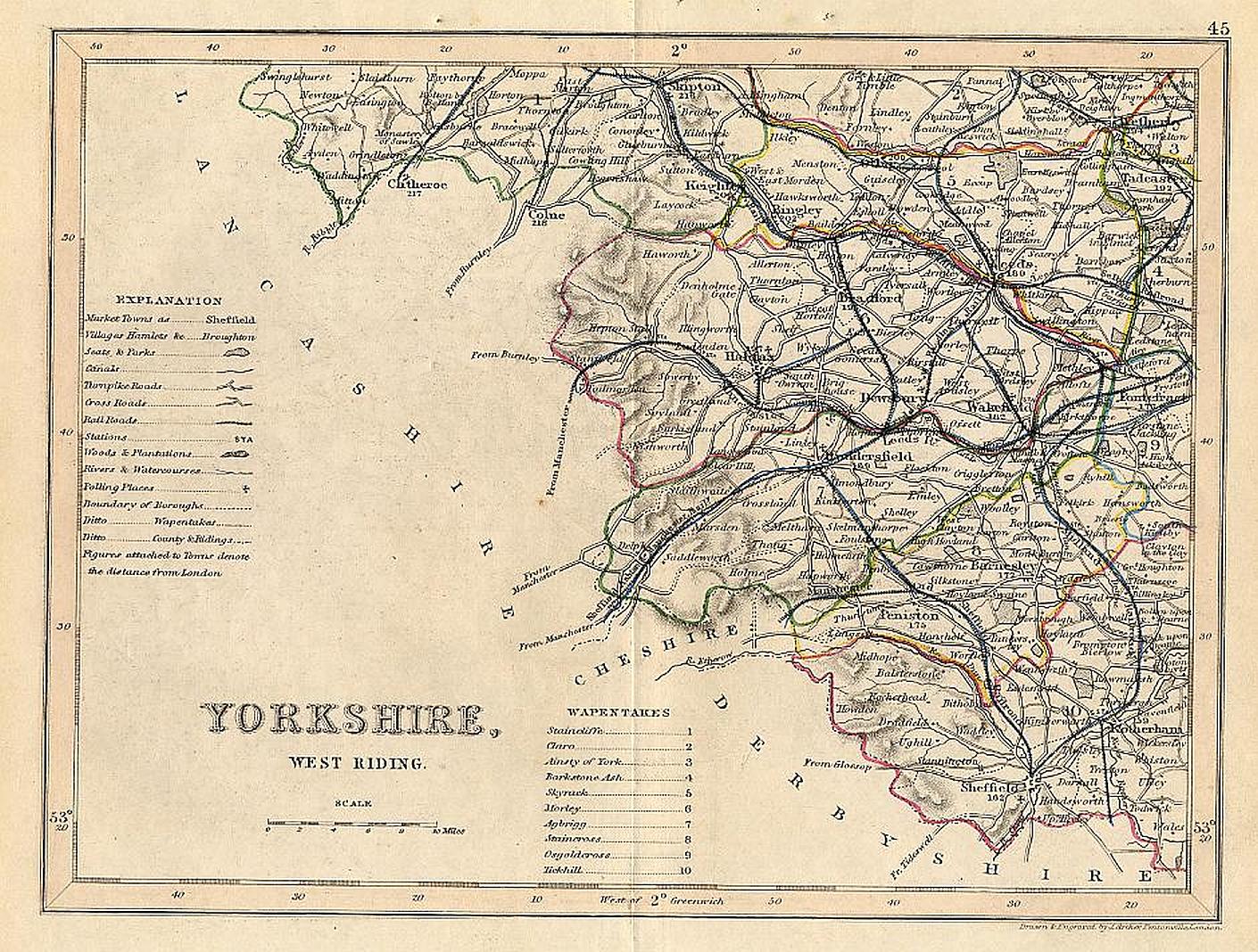
West Riding of Yorkshire 1843 Joshua Archer
East Riding of Yorkshire 1850 Robert Creighton with J & C Walker (Chubb p.322 CCCCLXIV)
Plans of Hartlepool and Whitby 1850 Alexander Fullarton
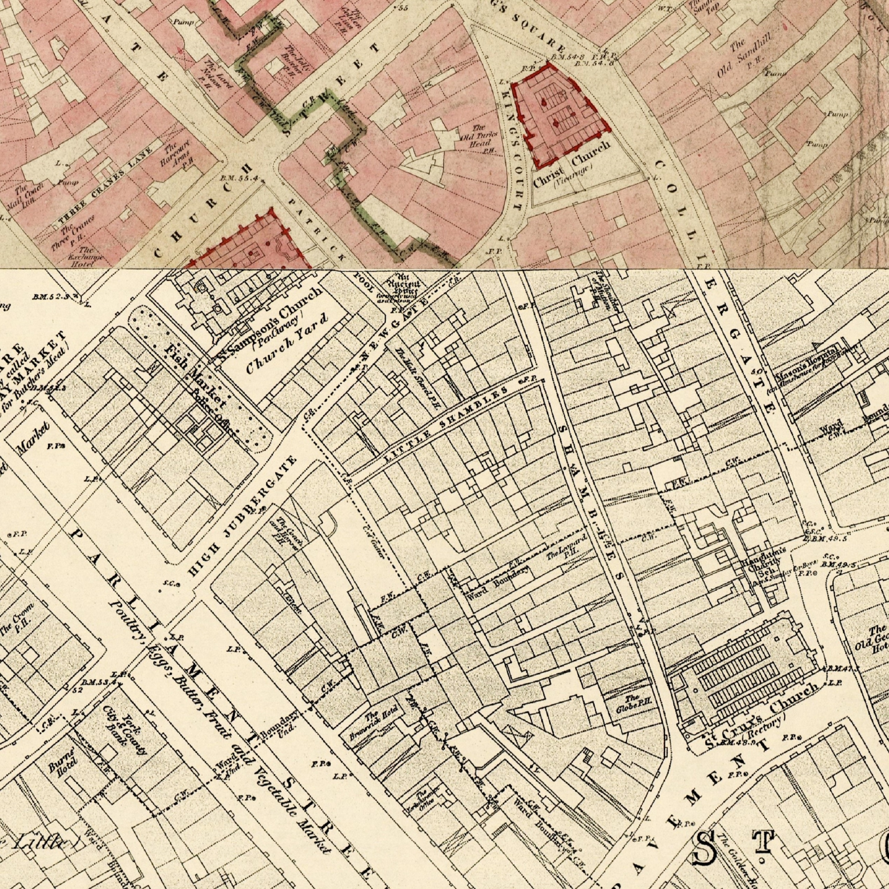
The Shambles York 1852
(Image courtesy of The British Library King's Collection)
York 1856 A Guide for strangers and visitors through the City of York anon.
(Image courtesy of The British Library King's Collection)
Visitor's guide to Harrogate Ripon and adjoining country, etc 1858 anon (Image courtesy of The Mechanical Curator & Wikimedia)
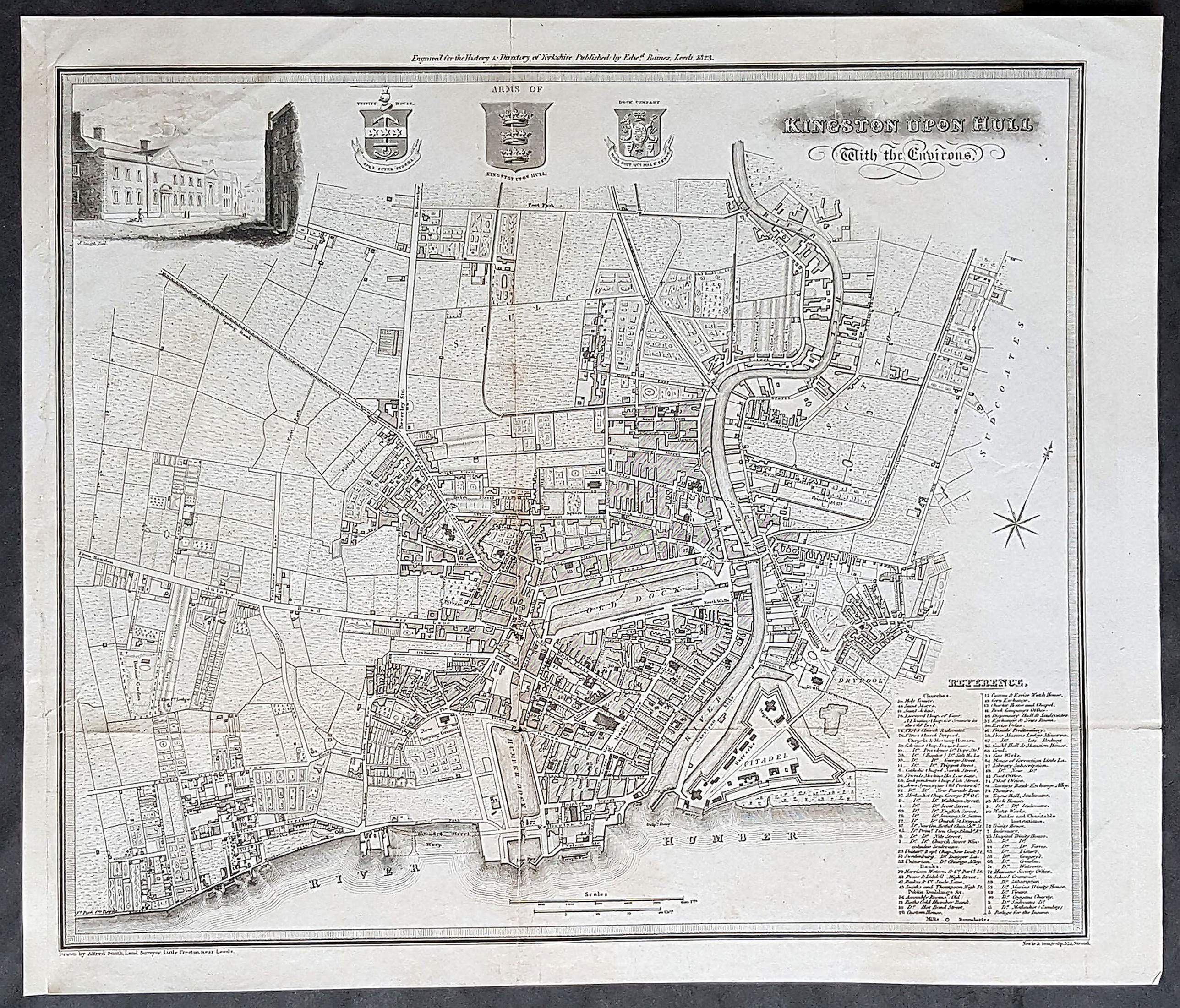
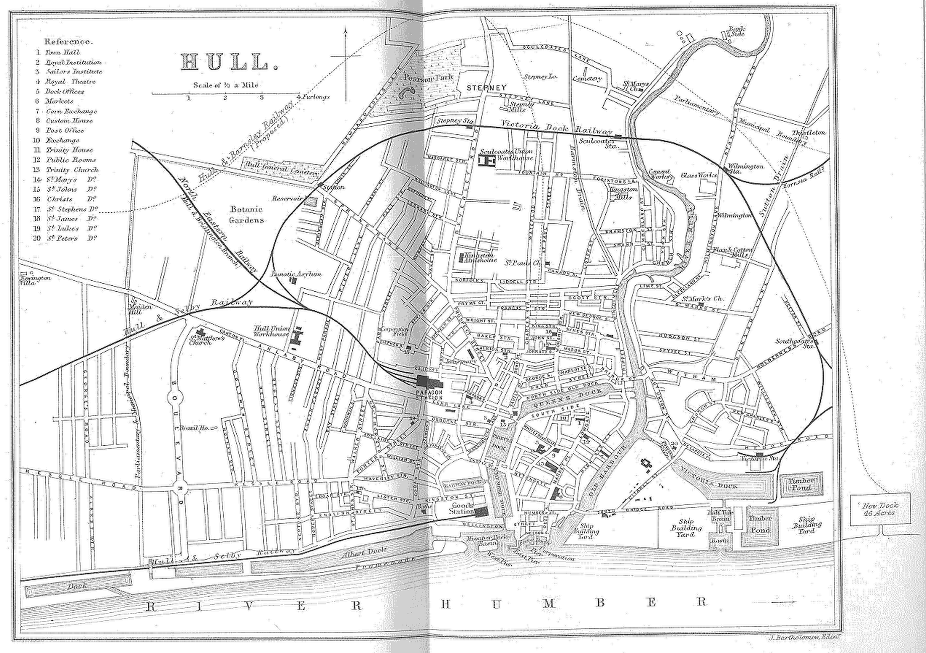
History of the town and port of Kingston-upon-Hull 1866 James Josepph Sheahan (Image courtesy of The British Library King's Collection)
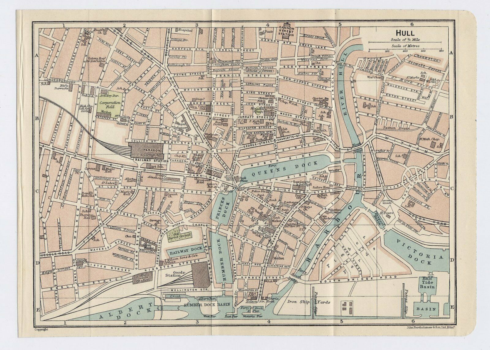
Plan of Hull 1883 George Bartholomew
Plan of Leeds 1874 Walter G. Blackie in The Imperial Gazetteer
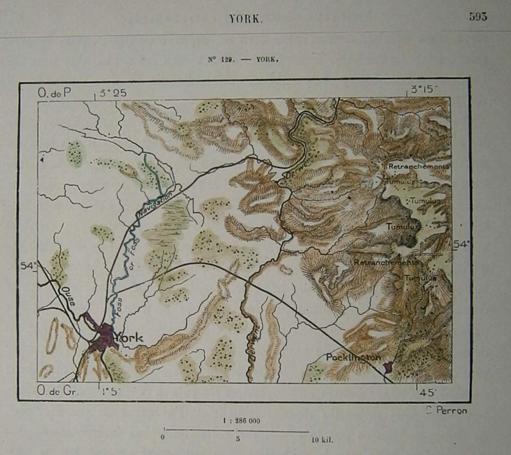
Yorkshire North Riding 1879 Perron_
Plan of Huddersfield 1883 Adam Black in Black's Guide To England and Wales
Plan of Hull 1883 Adam Black in Black's Guide To England and Wales
Plan of Leeds 1883 Adam Black in Black's Guide To England and Wales
Plan of Newcastle 1883 Adam Black in Black's Guide To England and Wales
Plan of Sheffield 1883 Adam Black in Black's Guide To England and Wales
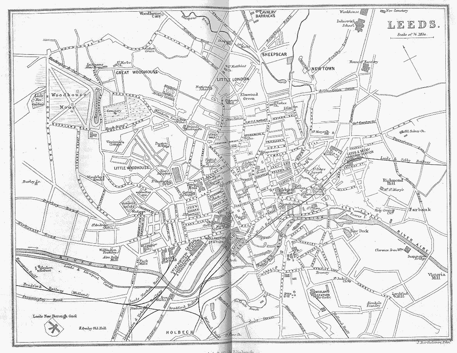
Leeds 1884 (Left Sheet) A + C Black
Leeds 1884 (Right Sheet) A + C Black
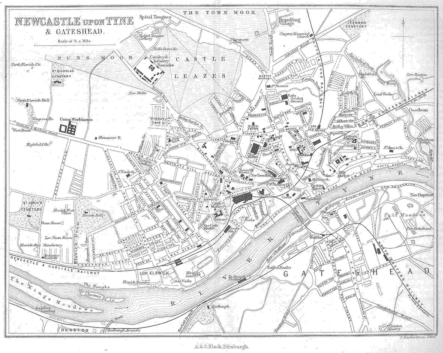
Newcastle upon Tyne and Gateshead 1884
(Left Sheet) (Right Sheet)
A. & C. Black (Image courtesy of The Mechanical Curator & Wikimedia)
City of York 1884
(Left Sheet) (Right Sheet)
A. & C. Black (Image courtesy of The Mechanical Curator & Wikimedia)Halifax 1884 A. & C. Black (Image courtesy of The Mechanical Curator & Wikimedia)
Middlesborough and Stockton on Tees 1885
Insurance Map of Leeds 1886 Charles Goad
Wharfdale 1888 Fred Cobley in Upper and Lower Wharfedale illustrated
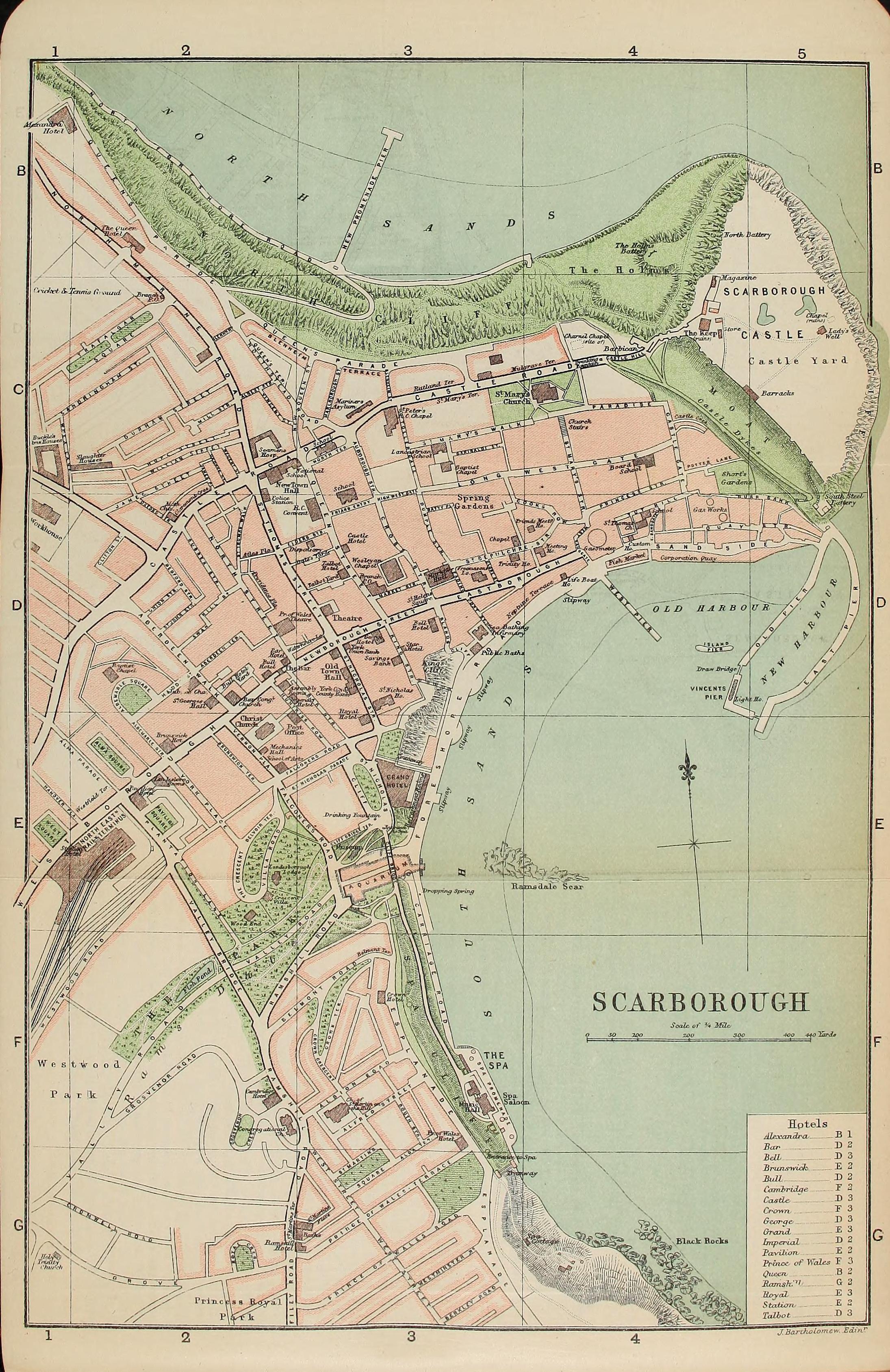
Scarborough 1890 George Bartholomew
Insurance Plan of Dewsbury 1893
(Image courtesy of the British Library )Yorks sheet 7 (BL_147817)
Insurance Plan of Leeds 1893 Vol._II;_sheet_62_(BL_149138)
(image courtesy of The British Library)Insurance Plan of Hull 1893 (Yorkshire) Vol _II;_sheet_28 (BL_148951)
(image courtesy of The British Library)
Plan of Huddersfield 1896 Adam Black in Black's Guide to England and Wales
Plan of Hull 1898 Newnes
Plan of Harrogate 1898 George Bartholomew
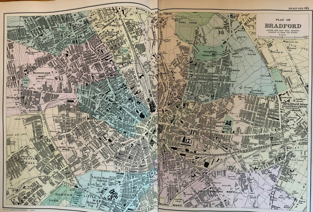
A Plan of Bradford 1907 Bacon
A Plan of Leeds 1909 G. Bartholomew
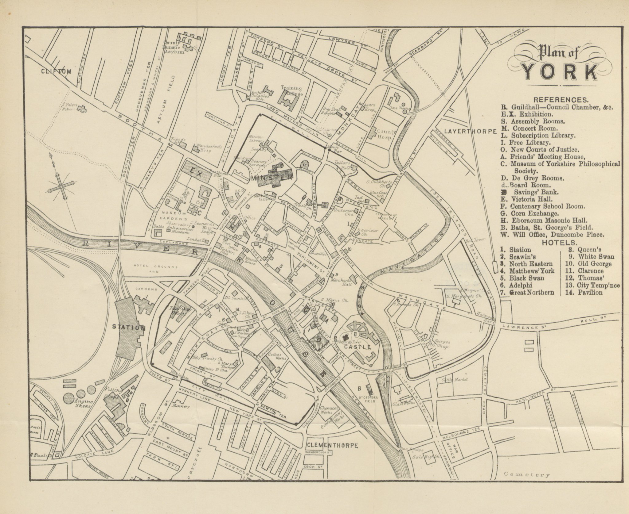
Plan of York 1910 George Bartholomew
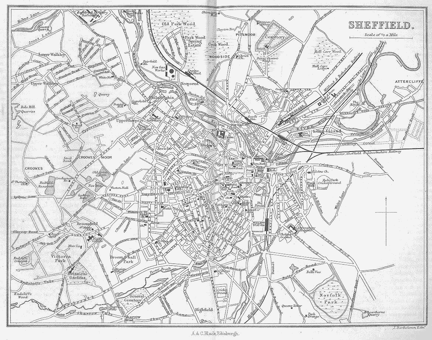
Sheffield 1924 George Bartholomew
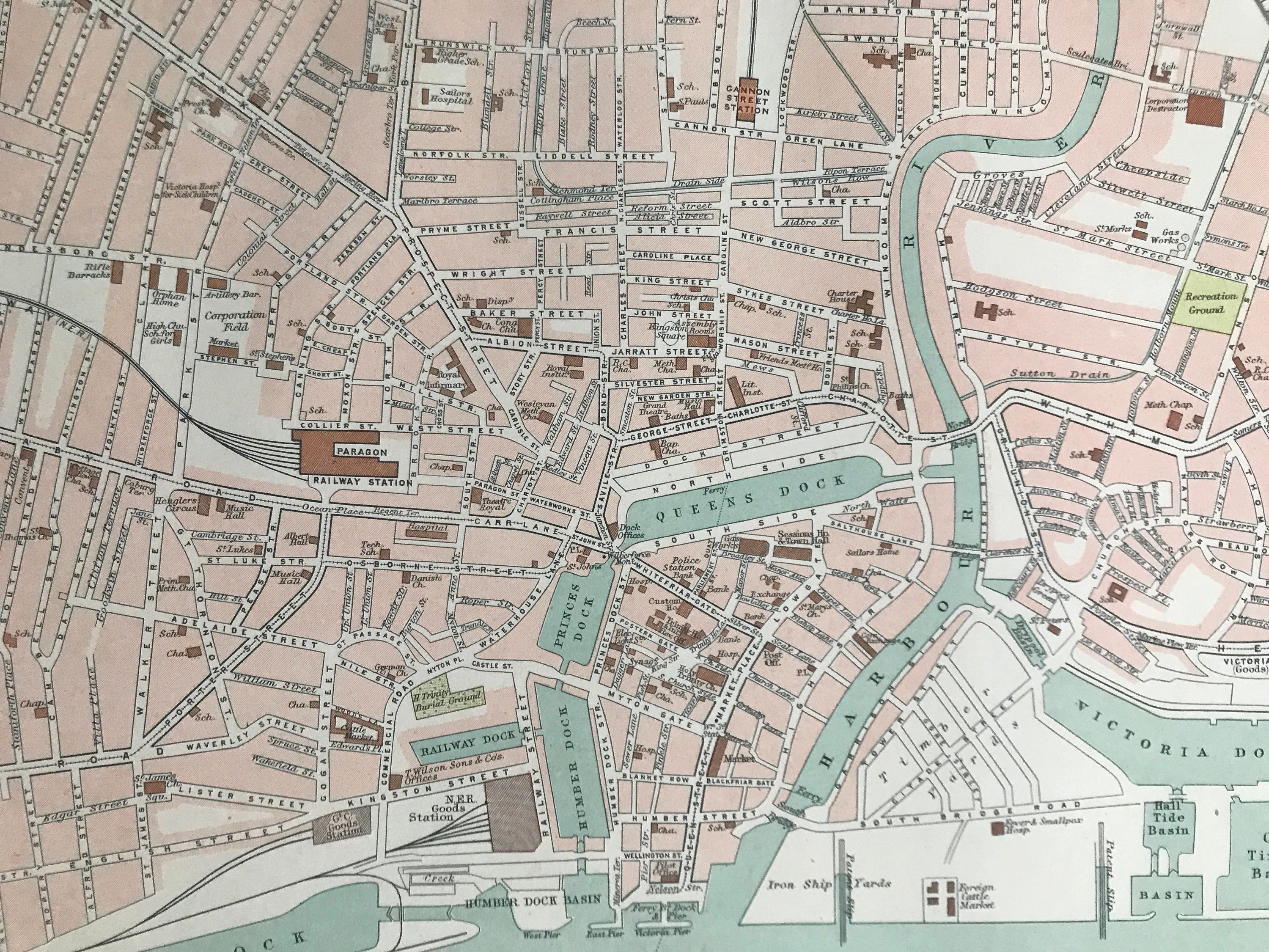
Hull 1924 George Bartholomew
.jpg)
.jpg)
%20(Image%20courtesy%20of%20The%20British%20Library%20Maps%20K.TOP.32.50.jpg)
%20%20.jpg)
(Image%20courtesy%20of%20The%20British%20Library%20King's%20Collection).jpg)
(Image%20courtesy%20of%20The%20British%20Library%20King's%20Collection).jpg)
.jpg)
.jpg.jpg)
%20.jpg)
%20.jpg)
.%20.jpg)
.jpg)
.jpg)
1733%20R.%20Gosling%20%20(Image%20courtesy%20of%20The%20British%20Library%20King's%20Collection%20Maps%20K.TOP.44.20.1.).jpg)
.jpg)
.jpg)
%20%201736%20%20Gosling%20.jpg)
.jpg)
L%20%20-%20Copy.jpg)
.jpg)
%20.jpg)
.jpg)
.jpg)
.jpg)
%201832%20Robert%20Kearsley%20Dawson%20for%20Plans%20of%20the%20Cities%20and%20Boroughs%20ofEngland%20and%20Wales%20.jpg)
(Image%20courtesy%20of%20The%20British%20Library%20King's%20Collection).jpg)
%20(Image%20courtesy%20of%20www.davidrumsey.com).jpg)
%20(Image%20courtesy%20of%20www.davidrumsey.com).jpg)
%20.jpg)
%20.jpg)
.jpg)
.jpg)
%20.jpg)
%20.jpg)
%20.jpg)
%20.jpg)
%20.jpg)
.tiff.jpg)
.tiff.jpg)
%20Vol%20_II%3b_sheet_28%20(BL_148951).tiff.jpg)